 Venice of the East, Reborn: Bangkok’s Plan to Reclaim Its 1,100 Canals as Linear Parks
THIS NEWS ARTICLE KINDLY SPONSORED BY FALLPROTEC, A WORLD-RENOWNED NAME IN THE DESIGN AND MANUFACTURE OF PREMIUM FALL PROTECTION SYSTEMS AND HEIGHT ACCESS SOLUTIONS
- Bangkok is implementing a “Blue & Green Network” plan to convert its 1,100 neglected canals into walkable, biodiverse linear parks, reversing a past policy of paving them over for roads.
- The initiative is being rolled out through pilot projects, such as the 4.5-kilometre Chong Nonsi Canal Park, which integrates walkways, water treatment systems, and public transit connectivity.
- Beyond creating public amenities, the project serves as critical climate infrastructure designed to mitigate flooding and manage water in a city that is sinking and facing rising sea levels.
Bangkok’s BMA is reclaiming 1,100 neglected canals as walkable public corridors — reversing half a century of car-centric concrete in a city that sinks two centimetres every year.
For much of the second half of the twentieth century, Bangkok pursued a single spatial strategy: concrete. Canals that had once served as the city’s lifeblood — markets, temples, and communities built along their banks — were filled in and paved over to accommodate the car.
The “Venice of the East” became a case study in urban heat, seasonal flooding, and the absence of accessible green space. Today, a deliberate reversal is under way.
The Bangkok Metropolitan Administration’s Blue & Green Network — its guiding concept described as “Revitalising City, Connecting Quarters, Weaving the Future” — is the most ambitious reordering of Bangkok’s public realm in decades.
The BMA, in partnership with landscape architects, civic planners, and international researchers, is seeking to transform the city’s more than 1,100 canals (khlongs) from neglected drainage channels into walkable, biodiverse Linear Parks. Five pilot projects launched simultaneously, each targeting a different part of the city’s waterway fabric.
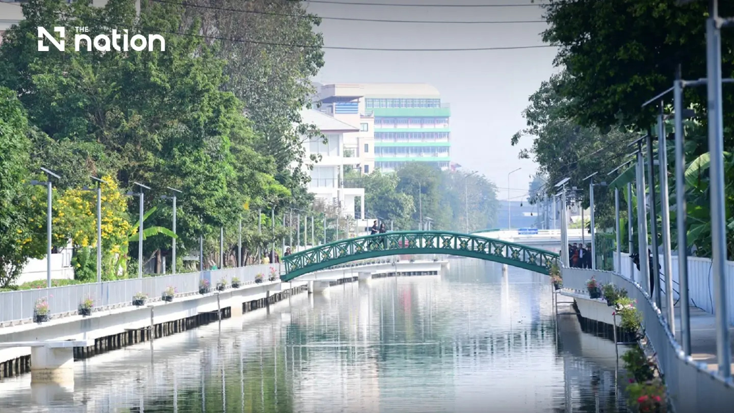
The highest-profile of these is the 4.5-kilometre Chong Nonsi Canal Park, which cuts through Bangkok’s central business district. Designed by landscape architect Kotchakorn Voraakhom of LANDPROCESS and modelled in part on Seoul’s Cheonggyecheon Restoration Project, the park connects the CBD to dense residential neighbourhoods across three districts.
It was the first canal park of its kind in Thailand, integrating pedestrian walkways, water plants, nature-based treatment systems, and BRT lane connectivity into a continuous blue-green corridor.
The Stockholm Environment Institute, which conducted early 2025 fieldwork across Bangkok’s pocket parks, offered a nuanced assessment of Chong Nonsi.
 The park attracts significant foot traffic — particularly in the late afternoon and evenings — but critics noted that construction replaced 30-year-old native trees with smaller non-native species and increased concrete coverage and that water quality improvements had been slower than anticipated.
The SEI concluded that for nature-based solutions to be truly transformational, form must not take precedence over function, and communities must be genuinely engaged in design decisions.
The second major axis of the Blue & Green programme targets Bangkok’s historic inner-city waterways, notably the 5.5-kilometre Phadung Krung Kasem canal.
Winding past Hua Lamphong railway station and through the old city gates, this project emphasises heritage preservation alongside walkability and micromobility.
A 1.25-kilometre priority stretch from Charoen Sawat Bridge to Kasatsuek Bridge has been prioritised for early-phase development.
The urgency behind these projects is scientific. Bangkok sits on soft alluvial soils and subsides at roughly two centimetres per year.
The IPCC projects global sea levels to rise 33 centimetres by 2050. In this context, every canal park is also a flood buffer, a water management asset, and a carbon sink.
Kotchakorn’s team has noted that their water management strategies are designed to absorb rainfall from 50- to 100-year precipitation events – a benchmark that places Bangkok’s canal parks firmly in the category of critical climate infrastructure, not simply a pleasant public amenity.
Source: https://www.nationthailand.com/thailand/bangkok/40068526
Google Translation:
เวนิสแห่งตะวันออก กลับมาเกิดใหม่: แผนของกรุงเทพฯ ฟื้นฟูคลอง 1,100 แห่งให้เป็นสวนสาธารณะริมคลอง
บทความข่าวนี้ได้รับการสนับสนุนโดย FALLPROTEC บริษัทชั้นนำระดับโลกด้านการออกแบบและผลิตระบบป้องกันการตกจากที่สูงและโซลูชันการเข้าถึงที่สูงระดับพรีเมียม
กรุงเทพฯ กำลังดำเนินการตามแผน “เครือข่ายสีน้ำเงินและสีเขียว” เพื่อเปลี่ยนคลองที่ถูกละเลย 1,100 แห่งให้เป็นสวนสาธารณะริมคลองที่สามารถเดินได้และมีความหลากหลายทางชีวภาพ ซึ่งเป็นการพลิกกลับนโยบายในอดีตที่เคยถมคลองเหล่านี้เพื่อสร้างถนน
โครงการริเริ่มนี้กำลังดำเนินการผ่านโครงการนำร่อง เช่น สวนคลองโนนสี ระยะทาง 4.5 กิโลเมตร ซึ่งบูรณาการทางเดิน ระบบบำบัดน้ำ และการเชื่อมต่อระบบขนส่งสาธารณะ
นอกเหนือจากการสร้างสิ่งอำนวยความสะดวกสาธารณะแล้ว โครงการนี้ยังทำหน้าที่เป็นโครงสร้างพื้นฐานด้านสภาพภูมิอากาศที่สำคัญ ซึ่งออกแบบมาเพื่อบรรเทาปัญหาน้ำท่วมและจัดการน้ำในเมืองที่กำลังทรุดตัวและเผชิญกับระดับน้ำทะเลที่สูงขึ้น
กรุงเทพมหานครกำลังฟื้นฟูคลองที่ถูกละเลยกว่า 1,100 แห่ง ให้เป็นทางเดินสาธารณะที่เข้าถึงได้ง่าย ซึ่งเป็นการพลิกผันจากนโยบายการใช้พื้นที่คอนกรีตที่เน้นรถยนต์เป็นหลักมานานกว่าครึ่งศตวรรษ ในเมืองที่ทรุดตัวลงปีละสองเซนติเมตร
ในช่วงครึ่งหลังของศตวรรษที่ 20 กรุงเทพฯ ดำเนินนโยบายด้านพื้นที่เพียงอย่างเดียว นั่นคือ การสร้างถนนคอนกรีต คลองที่เคยเป็นเส้นเลือดใหญ่ของเมือง ทั้งตลาด วัด และชุมชนที่สร้างอยู่ริมฝั่ง ถูกถมและปูด้วยคอนกรีตเพื่อรองรับรถยนต์
“เวนิสแห่งตะวันออก” กลายเป็นกรณีศึกษาเรื่องความร้อนในเมือง น้ำท่วมตามฤดูกาล และการขาดแคลนพื้นที่สีเขียวที่เข้าถึงได้ง่าย ปัจจุบัน การพลิกผันอย่างตั้งใจกำลังดำเนินอยู่
เครือข่ายสีน้ำเงินและสีเขียวของกรุงเทพมหานคร ซึ่งมีแนวคิดหลักคือ “ฟื้นฟูเมือง เชื่อมต่อย่านต่างๆ สานอนาคต” เป็นการจัดระเบียบพื้นที่สาธารณะของกรุงเทพฯ ครั้งใหญ่ที่สุดในรอบหลายทศวรรษ
กรุงเทพมหานคร ร่วมกับสถาปนิกภูมิทัศน์ นักวางผังเมือง และนักวิจัยนานาชาติ กำลังดำเนินการเปลี่ยนคลองกว่า 1,100 แห่งในเมือง จากคลองระบายน้ำที่ถูกละเลย ให้กลายเป็นสวนสาธารณะเชิงเส้นที่มีความหลากหลายทางชีวภาพและสามารถเดินเล่นได้ โครงการนำร่อง 5 โครงการได้เปิดตัวพร้อมกัน โดยแต่ละโครงการมุ่งเป้าไปที่ส่วนต่างๆ ของระบบทางน้ำในเมือง
โครงการที่โดดเด่นที่สุดคือ สวนสาธารณะคลองโนนสี ความยาว 4.5 กิโลเมตร ซึ่งตัดผ่านย่านธุรกิจใจกลางกรุงเทพฯ ออกแบบโดยสถาปนิกภูมิทัศน์ โคชากร วรอาคม จาก LANDPROCESS และได้รับแรงบันดาลใจบางส่วนจากโครงการบูรณะคลองชองกเยชอนในกรุงโซล สวนสาธารณะแห่งนี้เชื่อมต่อย่านธุรกิจกับย่านที่อยู่อาศัยหนาแน่นใน 3 เขต
นับเป็นสวนสาธารณะคลองแห่งแรกในประเทศไทยที่บูรณาการทางเดินเท้า พืชน้ำ ระบบบำบัดน้ำเสียแบบธรรมชาติ และการเชื่อมต่อเลนรถโดยสารประจำทาง (BRT) เข้ากับทางเดินสีเขียวและสีน้ำเงินที่ต่อเนื่องกัน
สถาบันสิ่งแวดล้อมสตอกโฮล์ม (Stockholm Environment Institute) ซึ่งทำการสำรวจภาคสนามในช่วงต้นปี 2025 ในสวนสาธารณะขนาดเล็กทั่วกรุงเทพฯ ได้ให้การประเมินที่ละเอียดอ่อนเกี่ยวกับสวนหนองนนทรี
สวนแห่งนี้มีผู้คนสัญจรไปมาจำนวนมาก โดยเฉพาะในช่วงบ่ายแก่ๆ และเย็น แต่ผู้วิจารณ์ตั้งข้อสังเกตว่า การก่อสร้างได้แทนที่ต้นไม้พื้นเมืองอายุ 30 ปีด้วยพันธุ์ไม้ต่างถิ่นขนาดเล็กกว่า และเพิ่มพื้นที่คอนกรีตมากขึ้น และการปรับปรุงคุณภาพน้ำเป็นไปอย่างช้ากว่าที่คาดไว้
SEI สรุปว่า เพื่อให้แนวทางแก้ไขปัญหาโดยอาศัยธรรมชาติเกิดการเปลี่ยนแปลงอย่างแท้จริง รูปแบบต้องไม่สำคัญไปกว่าฟังก์ชัน และชุมชนต้องมีส่วนร่วมอย่างแท้จริงในการตัดสินใจด้านการออกแบบ
แกนหลักที่สองของโครงการ Blue & Green มุ่งเป้าไปที่ทางน้ำในใจกลางเมืองเก่าแก่ของกรุงเทพฯ โดยเฉพาะคลองผดุงกรุงเกษมที่มีความยาว 5.5 กิโลเมตร
โครงการนี้เน้นการอนุรักษ์มรดกควบคู่ไปกับการเดินเท้าและการคมนาคมขนาดเล็ก โดยผ่านสถานีรถไฟหัวลำโพงและประตูเมืองเก่า
ช่วงระยะทาง 1.25 กิโลเมตร จากสะพานเจริญสวัสดิ์ถึงสะพานเกษียร ได้รับการจัดลำดับความสำคัญสำหรับการพัฒนาในระยะเริ่มต้น
ความเร่งด่วนเบื้องหลังโครงการเหล่านี้มาจากเหตุผลทางวิทยาศาสตร์ กรุงเทพฯ ตั้งอยู่บนดินตะกอนอ่อนและทรุดตัวลงประมาณ 2 เซนติเมตรต่อปี
IPCC คาดการณ์ว่าระดับน้ำทะเลทั่วโลกจะสูงขึ้น 33 เซนติเมตรภายในปี 2050 ในบริบทนี้ สวนคลองทุกแห่งจึงเป็นทั้งแนวกันชนน้ำท่วม ทรัพย์สินด้านการจัดการน้ำ และแหล่งดูดซับคาร์บอน
ทีมงานของนายกษัชกรได้กล่าวว่า กลยุทธ์การจัดการน้ำของพวกเขานั้นออกแบบมาเพื่อรองรับปริมาณน้ำฝนจากเหตุการณ์ฝนตกหนักระดับ 50-100 ปี ซึ่งเป็นเกณฑ์มาตรฐานที่จัดให้สวนคลองในกรุงเทพฯ อยู่ในหมวดหมู่ของโครงสร้างพื้นฐานด้านสภาพภูมิอากาศที่สำคัญ ไม่ใช่เพียงแค่สถานที่พักผ่อนหย่อนใจสาธารณะที่น่ารื่นรมย์เท่านั้น