 Project for new 4-lane road connecting east-side and west-side of Koh Samui
THIS NEWS ARTICLE KINDLY SPONSORED BY FALLPROTEC, A WORLD-RENOWNED NAME IN THE DESIGN AND MANUFACTURE OF PREMIUM FALL PROTECTION SYSTEMS AND HEIGHT ACCESS SOLUTIONS
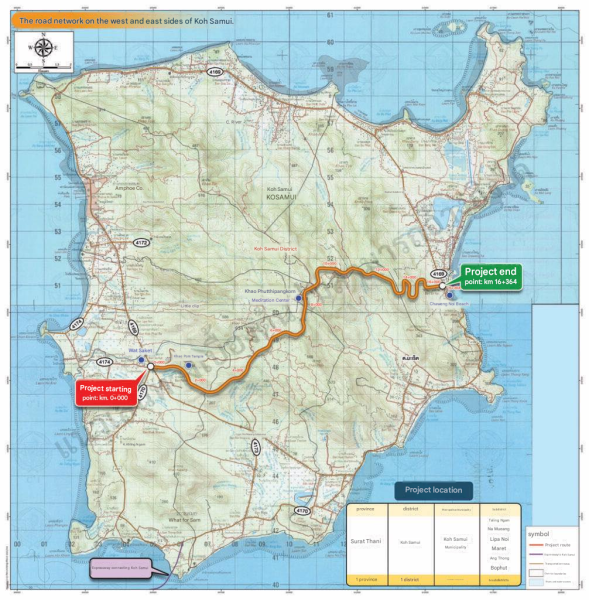
“Around Surat Thani Update” has shared project map with a new 4-lane road connecting east-side and west-side of Koh Samui between Chaweng Noi near Wat Saket, Bo Phut, and Taling Ngam near Sheraton Samui Hotel.
The English text below is a more detailed explanation from Mr. Tee Lawyer’s Facebook profile:
Feasibility Study and Environmental Impact Assessment (EIA) Report Preparation Project for the West–East Road Network Connection on Koh Samui.
Koh Samui, has its main transportation route as the Ring Road around the island (Highway No. 4169), which is approximately 50 km in length. At present, one of the major issues is the inconvenience of traveling between towns on the island.
Due to long travel distances and various geographical obstacles, travel times are considerably lengthy. As tourism is the primary industry of Koh Samui, the island’s tourism sector has been unable to fully develop because the transportation system is not yet sufficiently comprehensive or well connected. Furthermore, in emergency situations requiring travel to government centers on Koh Samui, such as medical emergencies requiring immediate access to hospitals, transportation cannot always be carried out promptly.
The Ministry of Transport assigned the Department of Rural Roads to conduct a feasibility study for the development of the rural highway network on Koh Samui. The study was completed in 2022. According to the study findings, the road connection linking Highway No. 4169 from the western side to the eastern side of the island (W–E Corridor) was identified as the highest-priority project under the Koh Samui rural highway network development plan.
The proposed route would provide several important benefits, including improving traffic flow and reducing congestion on the island’s main road network. The route would also connect the western ferry pier area to the airport on the eastern side of the island and serve as an important access route to key tourist attractions, such as Buddhadīpankara Meditation Center and Wat Saket.
Project Route Map – New Road Connecting the West and East Sides of Koh Samui.
The project aims to establish a more efficient transportation network on the island, reduce traffic congestion, and provide additional travel route options.
Route: Taling Ngam – Bo Phut
Project details:
Road type: 4-lane roadway
Project starting point: Area near Wat Saket
Project ending point: Area near Sheraton Samui Resort
Source: Around SURAT THANI Update»
Source: https://aseannow.com/topic/1394638-project-for-new-4-lane-road-connecting-east-west-samui
Google Translation:
บทความข่าวนี้ได้รับการสนับสนุนโดย FALLPROTEC บริษัทที่มีชื่อเสียงระดับโลกด้านการออกแบบและการผลิตระบบป้องกันการตกจากที่สูงและโซลูชันการเข้าถึงที่สูงระดับพรีเมียม
โครงการก่อสร้างถนน 4 เลนใหม่เชื่อมฝั่งตะวันออกและฝั่งตะวันตกของเกาะสมุย
บัญชี “อัปเดตพื้นที่สุราษฎร์ธานี” ได้แชร์แผนที่โครงการก่อสร้างถนน 4 เลนใหม่เชื่อมฝั่งตะวันออกและฝั่งตะวันตกของเกาะสมุย ระหว่างหาดเฉวงน้อยใกล้กับวัดสระเกศ บ่อผุด และหาดถลิ่งงามใกล้กับโรงแรมเชอราตันสมุย
ข้อความภาษาอังกฤษด้านล่างนี้เป็นคำอธิบายโดยละเอียดเพิ่มเติมจากโปรไฟล์เฟซบุ๊กของนายที ลอว์เยอร์:
โครงการศึกษาความเป็นไปได้และการจัดทำรายงานการประเมินผลกระทบสิ่งแวดล้อม (EIA) สำหรับการเชื่อมต่อเครือข่ายถนนตะวันตก-ตะวันออกบนเกาะสมุย
เกาะสมุยมีเส้นทางคมนาคมหลักคือถนนวงแหวนรอบเกาะ (ทางหลวงหมายเลข 4169) ซึ่งมีความยาวประมาณ 50 กิโลเมตร ปัจจุบันปัญหาสำคัญอย่างหนึ่งคือความไม่สะดวกในการเดินทางระหว่างเมืองต่างๆ บนเกาะ
เนื่องจากระยะทางในการเดินทางที่ยาวไกลและอุปสรรคทางภูมิศาสตร์ต่างๆ ทำให้เวลาในการเดินทางค่อนข้างนาน เนื่องจากการท่องเที่ยวเป็นอุตสาหกรรมหลักของเกาะสมุย แต่ภาคการท่องเที่ยวของเกาะยังไม่สามารถพัฒนาได้อย่างเต็มที่เพราะระบบขนส่งยังไม่ครอบคลุมหรือเชื่อมต่อกันได้ดีเพียงพอ นอกจากนี้ ในกรณีฉุกเฉินที่ต้องเดินทางไปยังศูนย์บริการของรัฐบาลบนเกาะสมุย เช่น กรณีฉุกเฉินทางการแพทย์ที่ต้องการเข้าถึงโรงพยาบาลอย่างเร่งด่วน การขนส่งก็ไม่สามารถทำได้อย่างทันท่วงทีเสมอไป
กระทรวงคมนาคมจึงมอบหมายให้กรมทางหลวงชนบททำการศึกษาความเป็นไปได้ในการพัฒนาระบบทางหลวงชนบทบนเกาะสมุย การศึกษาเสร็จสิ้นในปี 2565 จากผลการศึกษาพบว่า การเชื่อมต่อทางหลวงหมายเลข 4169 จากฝั่งตะวันตกไปยังฝั่งตะวันออกของเกาะ (เส้นทางตะวันตก-ตะวันออก) เป็นโครงการที่มีความสำคัญสูงสุดภายใต้แผนพัฒนาระบบทางหลวงชนบทของเกาะสมุย
เส้นทางที่เสนอจะให้ประโยชน์ที่สำคัญหลายประการ รวมถึงการปรับปรุงการไหลเวียนของจราจรและลดความแออัดบนเครือข่ายถนนสายหลักของเกาะ เส้นทางนี้จะเชื่อมต่อท่าเรือเฟอร์รี่ฝั่งตะวันตกกับสนามบินทางฝั่งตะวันออกของเกาะ และเป็นเส้นทางสำคัญในการเข้าถึงสถานที่ท่องเที่ยวสำคัญ เช่น ศูนย์ปฏิบัติธรรมพุทธดีปังกรา และวัดสระเกศ
แผนที่เส้นทางโครงการ – ถนนสายใหม่เชื่อมต่อฝั่งตะวันตกและตะวันออกของเกาะสมุย
โครงการนี้มีเป้าหมายเพื่อสร้างเครือข่ายการคมนาคมที่มีประสิทธิภาพมากขึ้นบนเกาะ ลดปัญหาการจราจรติดขัด และเพิ่มทางเลือกเส้นทางการเดินทาง
เส้นทาง: ตลิ่งงาม – บ่อผุด
รายละเอียดโครงการ:
ประเภทถนน: ถนน 4 เลน
จุดเริ่มต้นโครงการ: บริเวณใกล้กับวัดสระเกศ
จุดสิ้นสุดโครงการ: บริเวณใกล้กับเชอราตันสมุยรีสอร์ท
ที่มา: Around SURAT THANI Update»