A Comparison of Some Aspects of Thai Life Compared to UK Life on a Recent Trip to Manchester (Part 2)
NOTE: Part 1 offered a few comparisons between aspects UK and Thai life, while Part 2 only looks at a point of interest on the trip, local historical bridges.
Introduction
As I explained in Part 1, my wife and I recently spent almost two weeks visiting family in Manchester.
One of the first things that strikes anyone visiting Britain—whether as a tourist or an expatriate coming home—is the sheer weight of history that surrounds everyday life. Historic buildings are everywhere. Houses, farms, churches, pubs, bridges and industrial structures that have stood for centuries remain part of the modern landscape. Many date back hundreds of years; some have survived for almost two millennia.
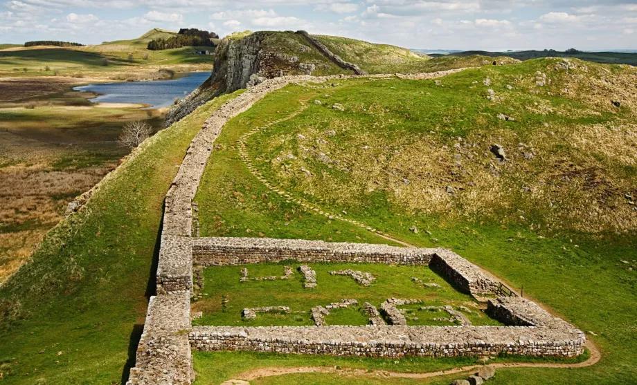
A perfect example is Hadrian’s Wall in Northumberland. Built on the orders of the Roman Emperor Hadrian beginning in AD 122 as the north-west frontier of the Roman Empire. Stretching 73 miles (117 km) from the River Tyne in the east to the Solway Firth in the west of northern England. It took approximately six years to construct, together with its forts, milecastles, watchtowers and defensive ditches. Remarkably, substantial sections still survive today. In 2026, the wall is already more than 1,900 years old, yet it remains one of Britain’s most impressive historic monuments.
Examples of this continuity with the past can be found almost everywhere. In my own village, the oldest surviving building dates from before 1347. Numerous houses and farms were built during the sixteenth century, while the oldest pub still operating as a pub was constructed in 1722 and proudly displays the datestone “TCH 1722” above its entrance. None of this is particularly unusual by British standards. Similar examples can be found in villages throughout the country.
To put this into perspective, some buildings in my village were already standing before the Pilgrims sailed from Plymouth aboard the Mayflower in 1620 and long before Captain James Cook explored New Zealand and the east coast of Australia.
During this latest trip home however, it was not the ancient houses or churches that particularly caught my attention, it was the bridges.
Britain possesses an extraordinary collection of historic bridges, viaducts and aqueducts, many of which continue to perform the very function for which they were originally built. For those involved in construction and engineering, these structures offer fascinating examples of projects that have stood the test of time.
1. Stockport Viaduct
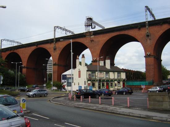
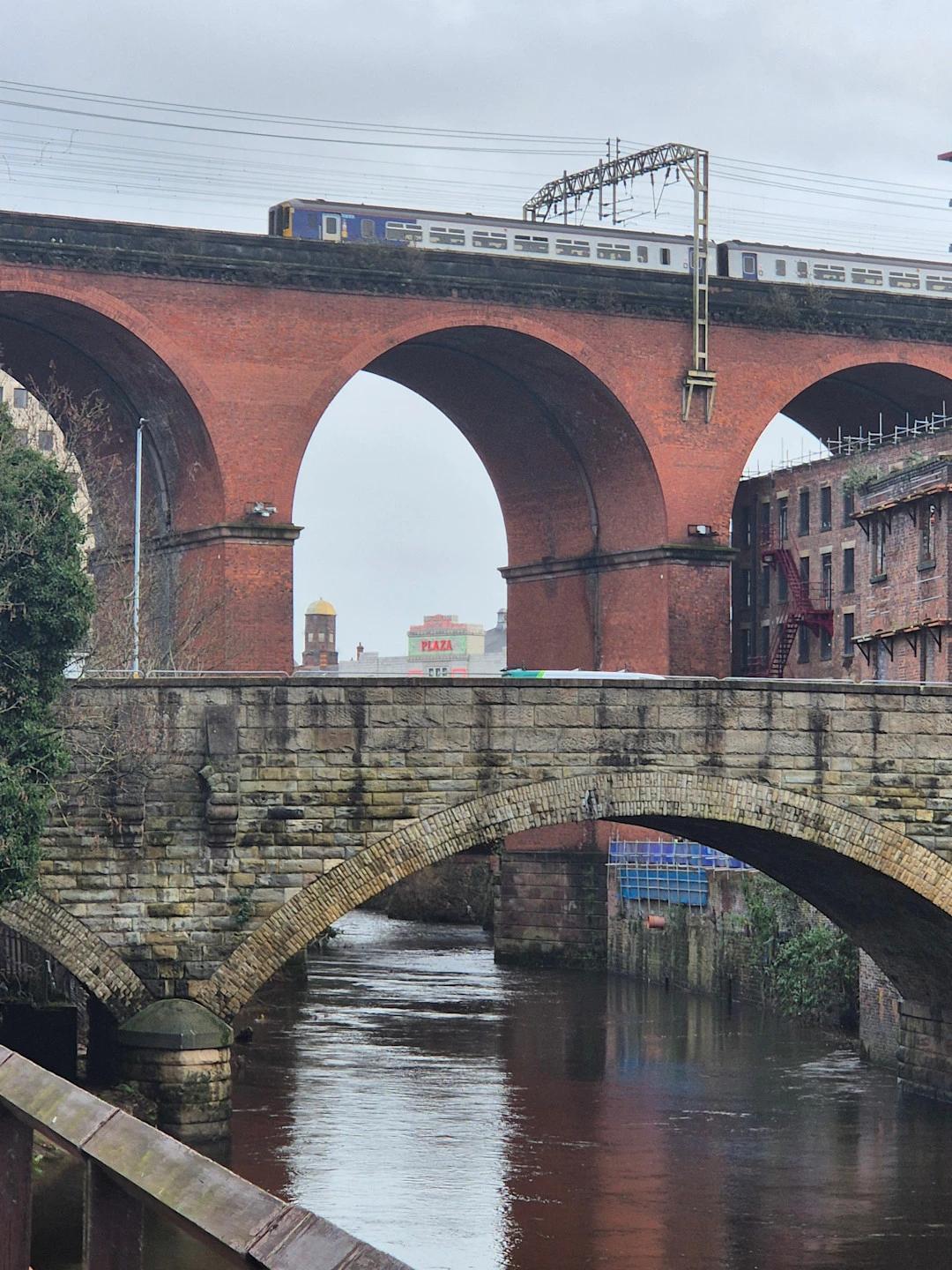
Perhaps the most famous bridge in my local area is Stockport Viaduct, a Grade II listed structure completed in 1840. Stretching 550 metres across the River Mersey valley and rising 34 metres above the River Mersey below, it remains one of the largest brick railway viaducts in the United Kingdom.
My wife has accompanied me on visits to Greater Manchester for almost thirty years and has seen most of the area’s major attractions. One place, however, had somehow escaped our itinerary until this trip: Stockport’s Hat Works, the United Kingdom’s only museum dedicated entirely to the hat-making industry.
At first glance, the connection between Stockport and hats may seem surprising. Yet throughout much of the nineteenth and early twentieth centuries, Stockport was one of the world’s most important centres of hat manufacture and the undisputed capital of Britain’s felt-hat industry.
At its peak:
- More than 100 hat factories operated in and around the town.
- Thousands of people worked in the trade.
- Millions of hats were produced each year.
- A substantial proportion of Britain’s felt hats were manufactured in Stockport.
- Stockport-made hats were exported throughout the world.
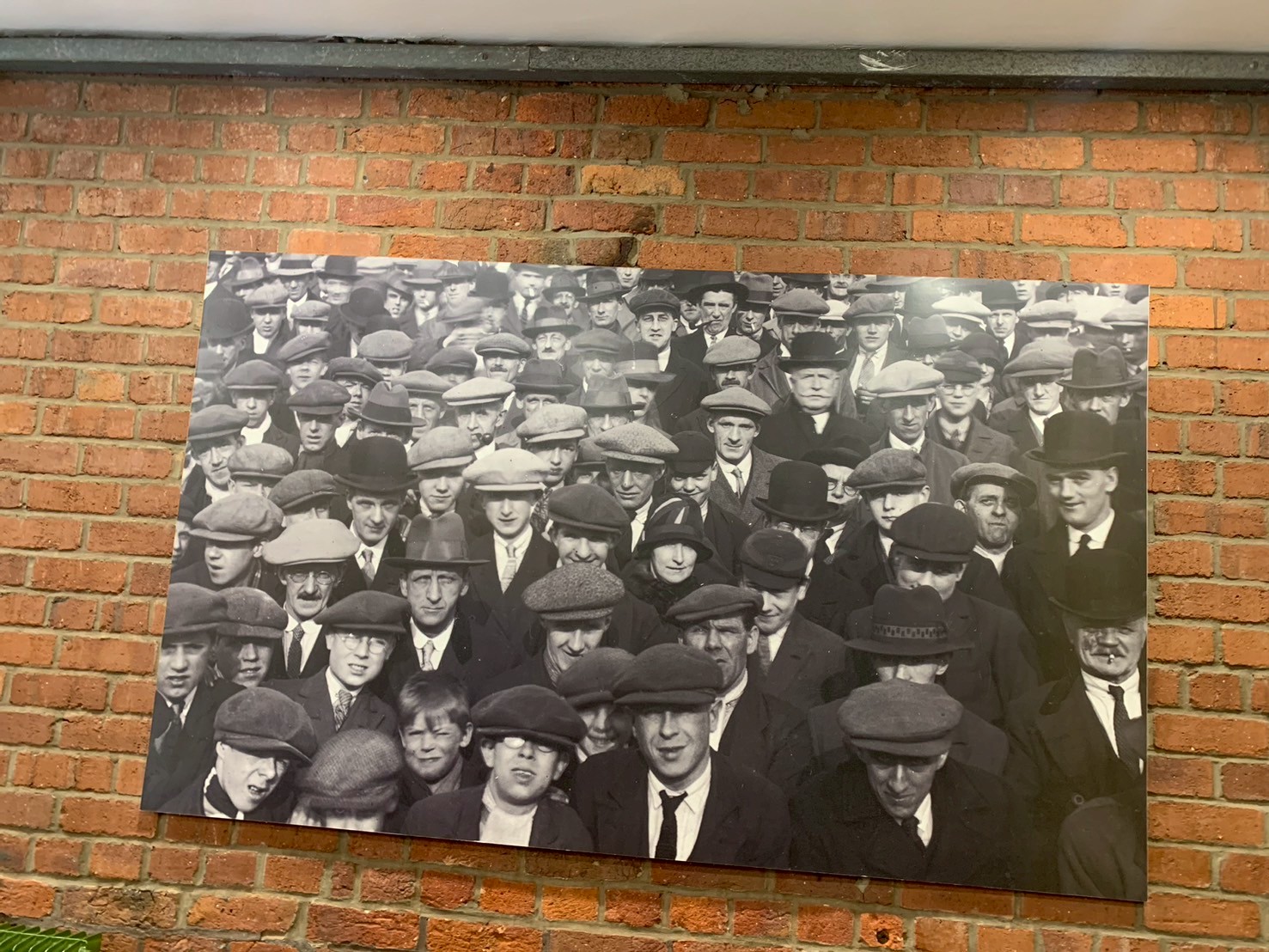
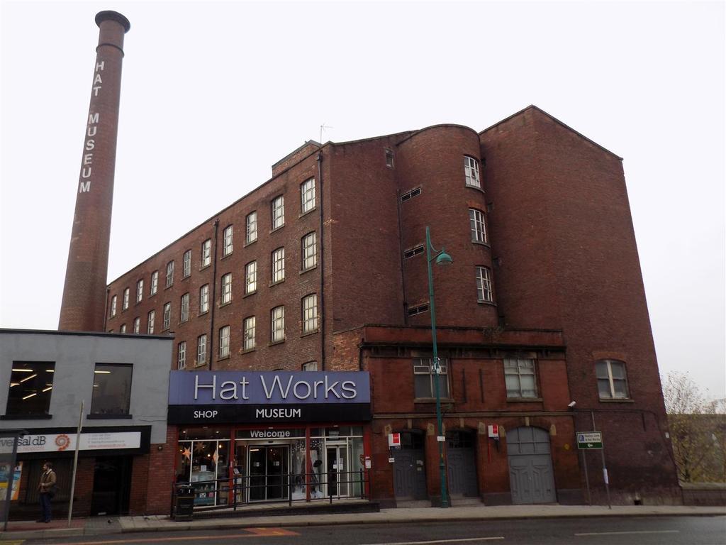
The town became particularly renowned for producing men’s felt hats, including bowlers, top hats and fedoras.
Like many traditional industries, however, the trade declined after the 1950s as hat-wearing gradually fell out of fashion. Demand fell, factories closed, employment declined and production increasingly moved overseas. By the end of the twentieth century, most of Stockport’s once-famous hat factories had disappeared.
Today, the Hat Works Museum, housed in a former Victorian hat factory, provides one of the best reminders of this important industrial heritage.
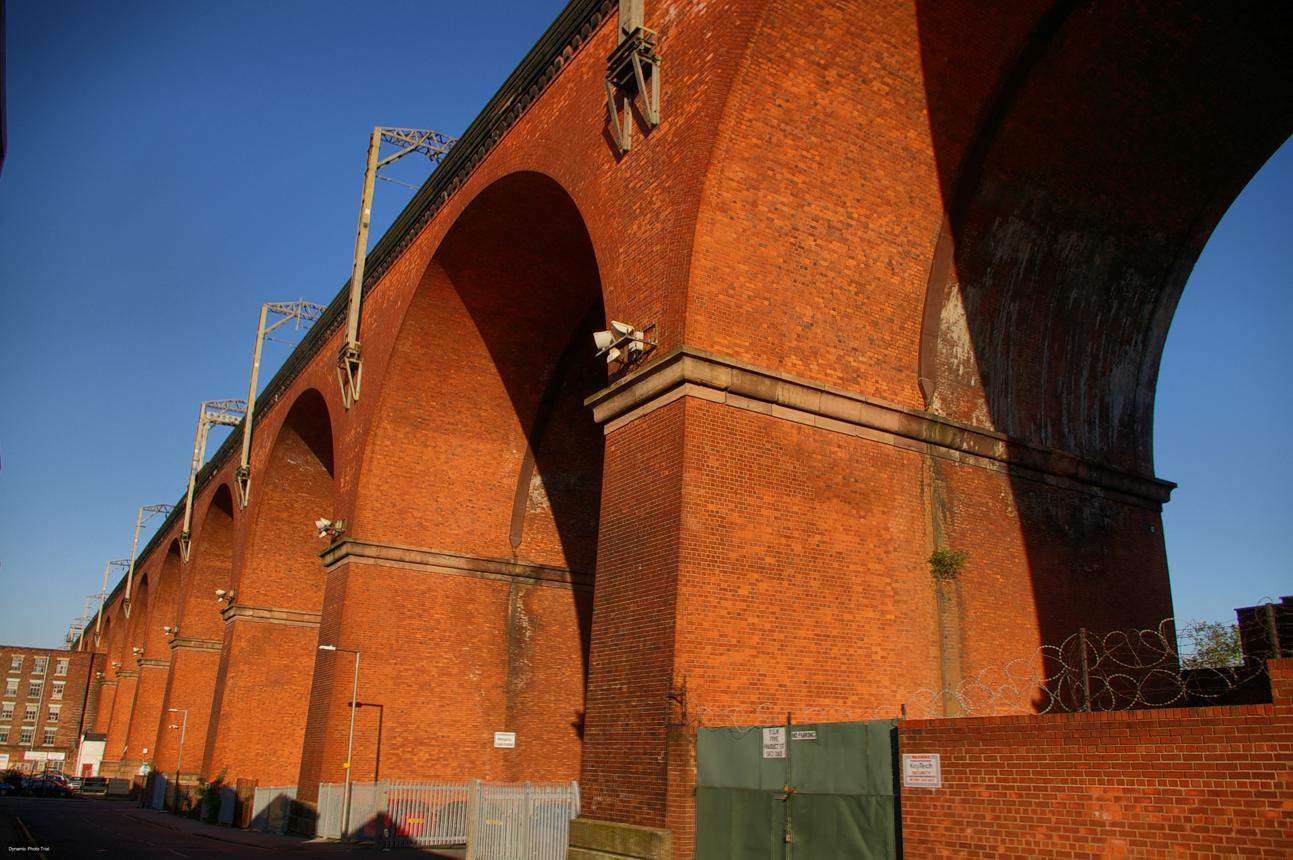
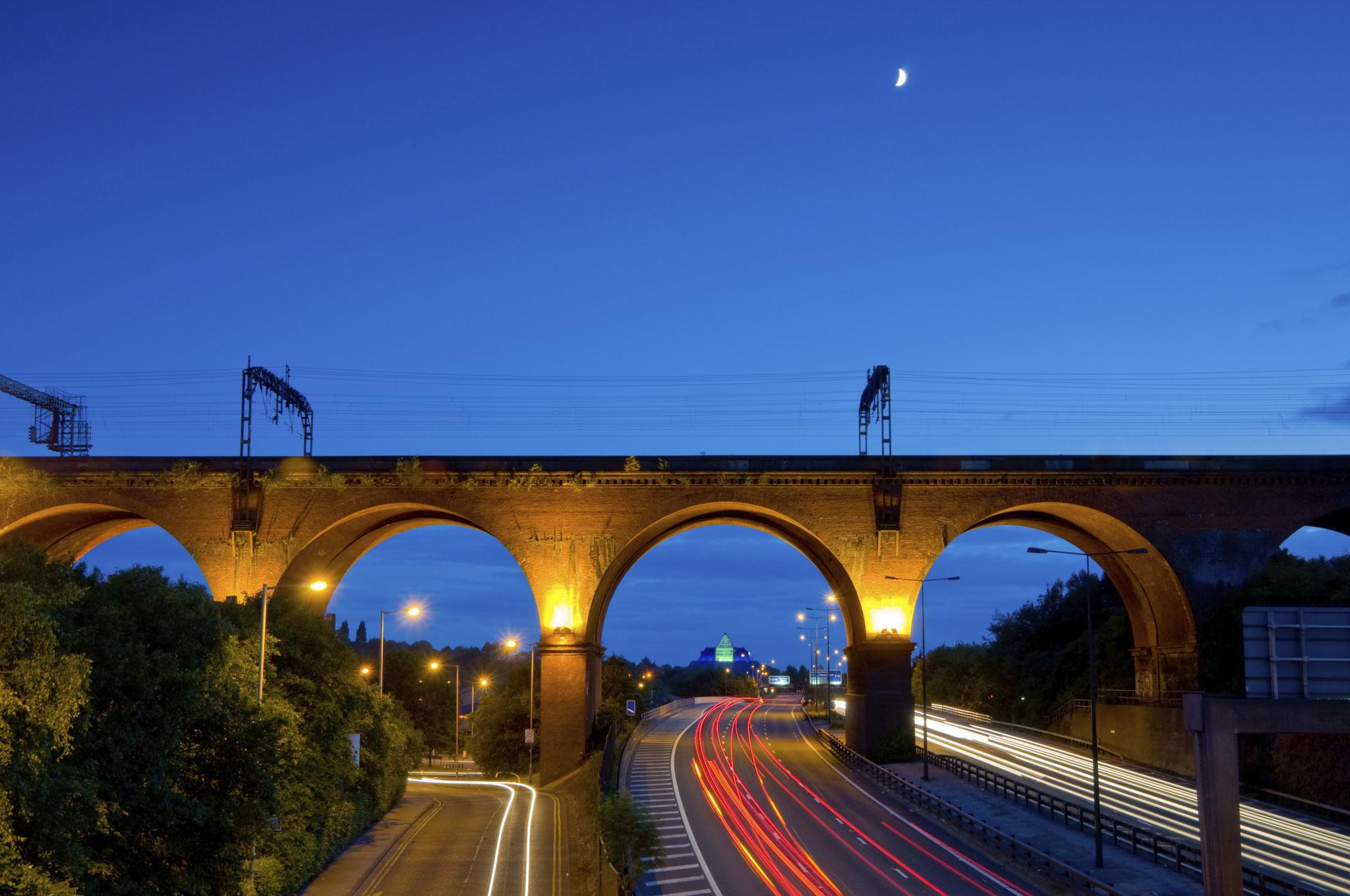
Towering above both the museum and Stockport town centre stands the viaduct itself.
Construction of Stockport Viaduct began in March 1839 and was completed just twenty-one months later in December 1840. Given the scale of the project and the challenges of building high above the River Mersey valley, this was a remarkable achievement.
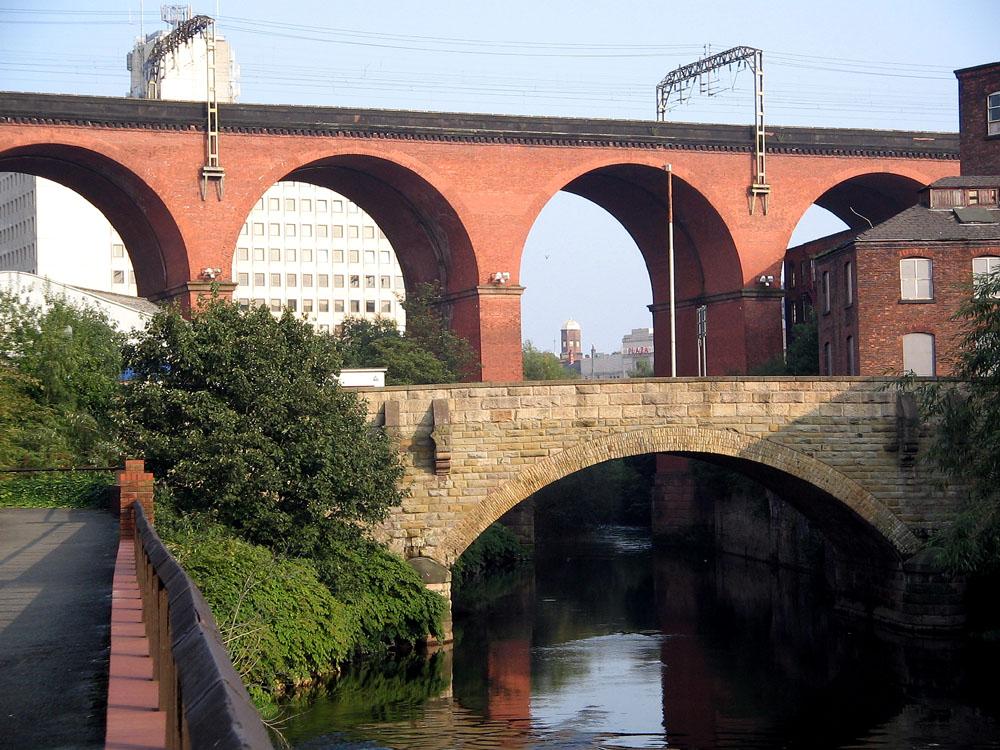
River Mersey, which is always linked to Liverpool, actually begins only a short distance away from Stockport Viaduct, at the confluence of where the Rivers Goyt and Tame meet in Stockport.
When completed, Stockport Viaduct was reputedly the largest viaduct in the world, one of the largest brick-built structures ever constructed and among the greatest engineering achievements of the early railway age. Approximately 600 men worked on its construction, using an astonishing eleven million bricks.
The structure consists of twenty-two semi-circular arches, each spanning 19.2 metres. These are supported by massive red-brick piers three metres thick, while smaller arches at either end provide additional stability. Originally built to carry two railway tracks, the viaduct was widened during the late 1880s to accommodate four tracks as railway traffic increased.
The viaduct formed a crucial part of the Manchester–Stockport railway line, which opened in June 1840. Direct services to Crewe and London followed in 1842, helping establish one of Britain’s most important transport corridors.
Nearly two centuries later, the viaduct remains a vital component of the national railway network. Almost 400 trains cross it every day as part of the West Coast Main Line.
What makes Stockport Viaduct especially impressive is not merely its size, but its longevity. After almost 187 years, it continues to fulfil precisely the role for which it was designed. It stands as a powerful reminder of the ambition, confidence and engineering excellence of the Victorian era.
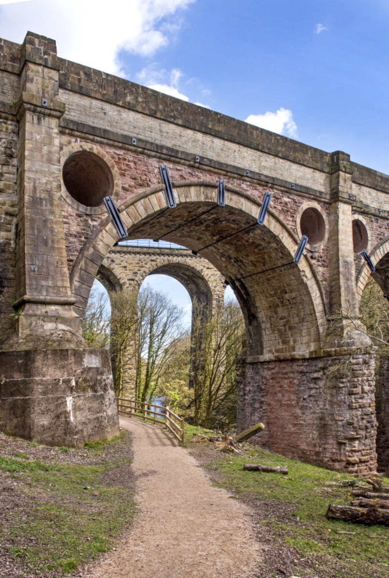 2. Marple Aqueduct and Marple Viaduct
While Stockport Viaduct is probably the most famous bridge in my area, my personal favourite is undoubtedly Marple Aqueduct.
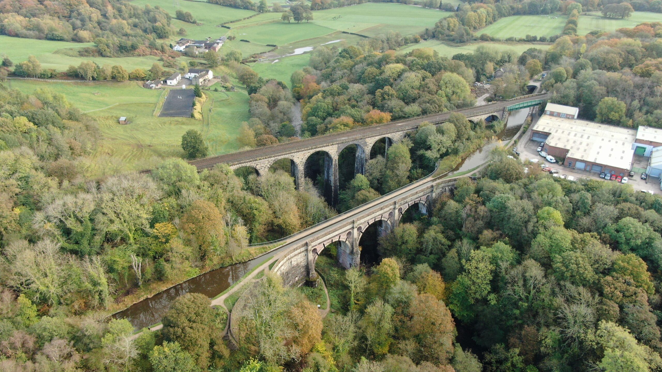
Whenever my wife and I return home, one walk that invariably finds its way into our itinerary is the beautiful stretch of the Peak Forest Canal between Marple and Romiley. The route combines attractive countryside with a fascinating glimpse into Britain’s industrial past. Along the way are Marple’s famous flight of sixteen canal locks, the impressive Marple Aqueduct and its equally striking neighbour, Marple Railway Viaduct.
Completed in 1800 as part of the Peak Forest Canal, the aqueduct was designed by Benjamin Outram, one of the leading canal engineers of the Industrial Revolution. Construction began in 1795, the arches were completed in 1799, and by 1800 canal boats were already passing high above the River Goyt.
To appreciate the significance of the aqueduct, it is necessary to understand the purpose of the canal itself.
During the late eighteenth century, Manchester was expanding at a remarkable rate. New factories, mills, roads and housing developments required enormous quantities of limestone, burnt lime for mortar and agriculture, coal and other raw materials. The Peak District around Buxton and Castleton possessed abundant limestone deposits, but transporting such heavy materials by horse and cart was slow, difficult and expensive. Canals offered a far more efficient solution.
The Peak Forest Canal was authorised by Parliament in 1794 and constructed between 1795 and 1800. Its primary purpose was to transport limestone, lime and other minerals from the Peak District into Manchester and the growing industrial settlements along its route.
One of the greatest challenge facing the canal’s engineers, was the deep valley of the River Goyt at Marple.
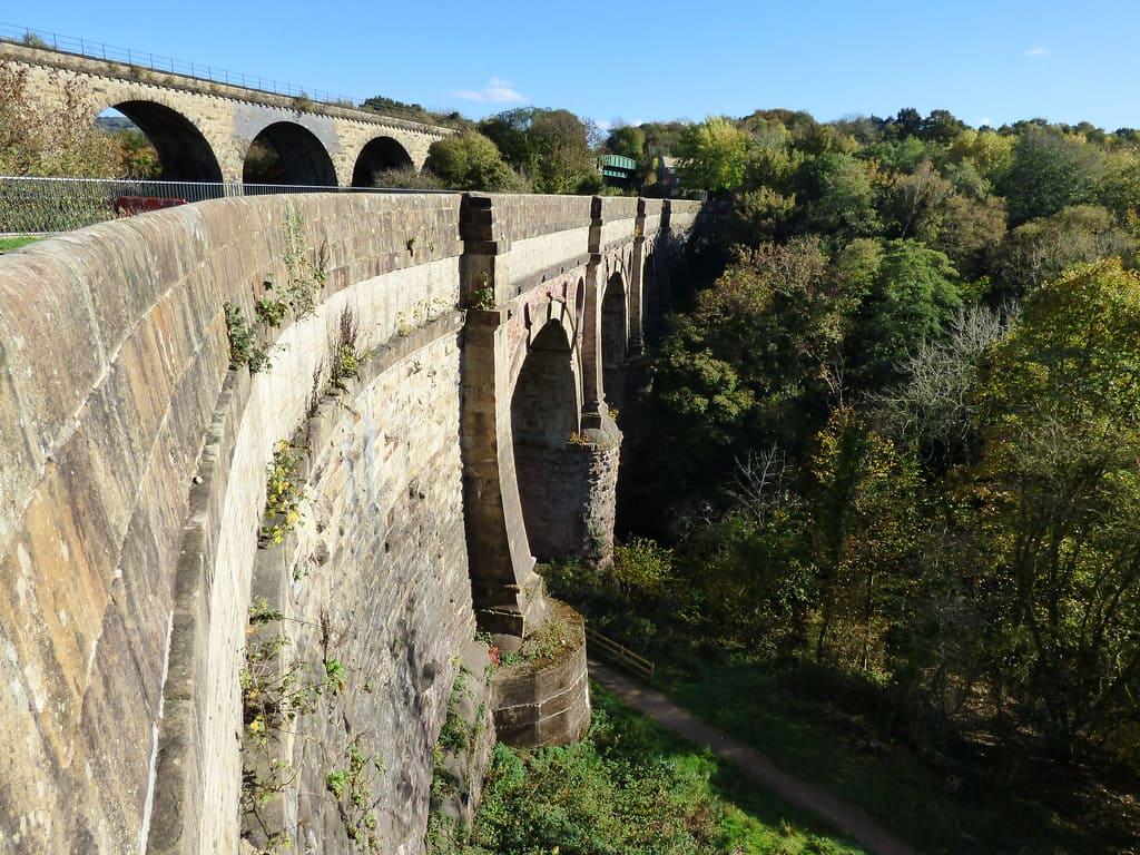
Rather than forcing boats to cross the valley using a lengthy series of locks, Outram proposed a bold solution. His aqueduct would carry the canal approximately thirty metres above the river, allowing boats to continue along an almost level route while saving considerable time and expense.
More than two centuries later, the Marple Aqueduct remains the highest canal aqueduct in England. It is both a Grade I listed structure and a Scheduled Monument, reflecting its importance as one of Britain’s most significant industrial heritage sites.
The scale of the structure is impressive even by modern standards. Measuring 94 metres in length and containing approximately 6,000 cubic metres of masonry, it is supported by three enormous semi-circular arches spanning the valley below. Standing on the towpath and looking down to the River Goyt some thirty metres beneath can still be a slightly unnerving experience.
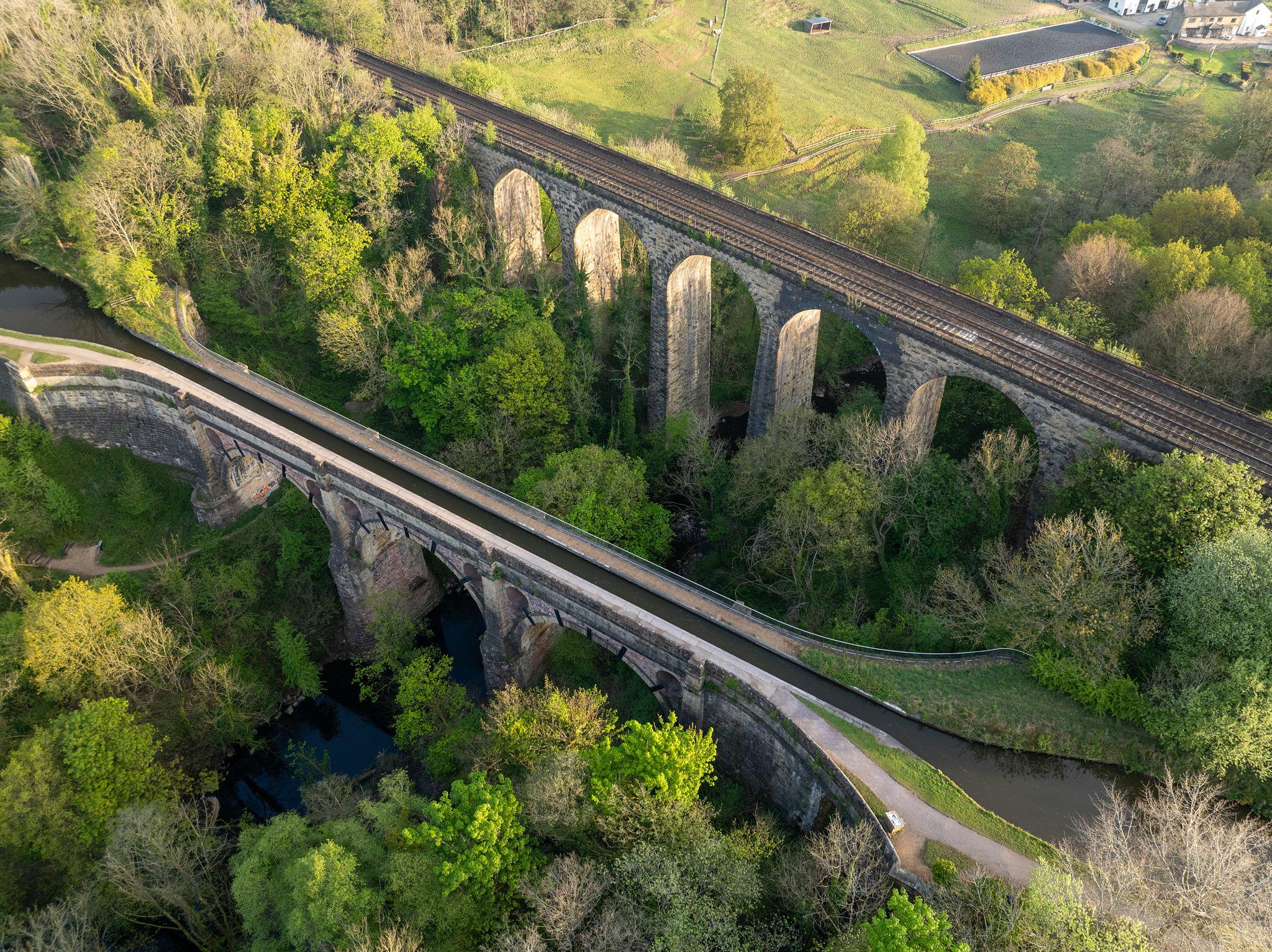
Historically, canal aqueducts were often designed with a protective parapet on the towpath side but little or no protection on the offside. Marple Aqueduct was built with no protection on the offside. Local lads, developed a tradition of daring each other to leap across the canal from the towpath side to the unprotected opposite side—a feat requiring considerably more courage than common sense.
Unfortunately, a number of serious incidents occurred during the 2010s, when individuals fell from the aqueduct into the valley below. In response, the Canal & River Trust commissioned a carefully designed metal parapet for the canal offside in 2017. The new barrier significantly improved safety while preserving the historic appearance of the structure.
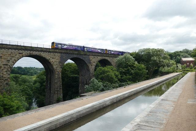
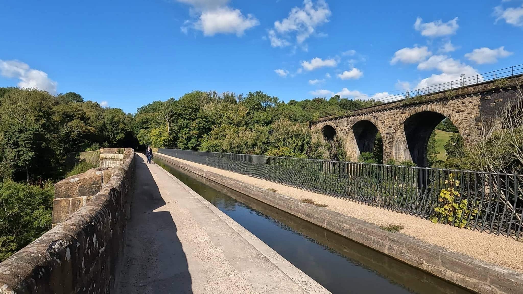
Running immediately alongside the aqueduct is its younger neighbour, the Marple Railway Viaduct, completed in 1863 for the Manchester, Sheffield and Lincolnshire Railway.
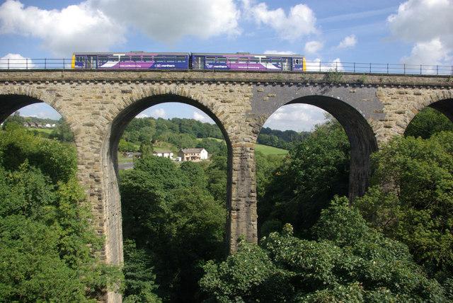
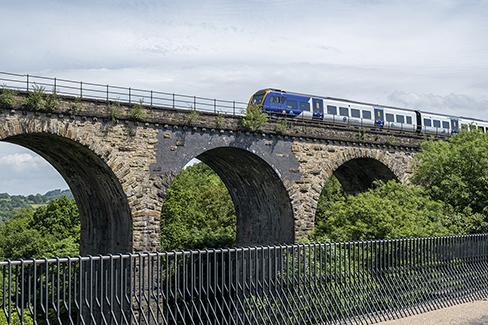
Like the aqueduct, the viaduct crosses the River Goyt at a considerable height. This Grade II listed structure stands approximately 38 metres above the river and consists of twelve stone arches together with a wrought-iron girder span. More than 160 years after its completion, it continues to carry trains between Manchester, New Mills and Sheffield (a different railway line from the one with the better-known Stockport Viaduct).
Few places illustrate Britain’s transport history quite so effectively as Marple. Within a matter of metres stand two major engineering achievements from different eras: one representing the great canal age of the late eighteenth century, the other symbolising the railway revolution of the nineteenth century. Each embodied the cutting-edge transport technology of its day, and both continue to fulfil their original purpose centuries later.
Marple also possesses an intriguing literary connection. It is widely believed that Agatha Christie drew inspiration from the village’s name when creating her famous fictional detective, Miss Marple, one of the most enduring characters in British crime fiction.
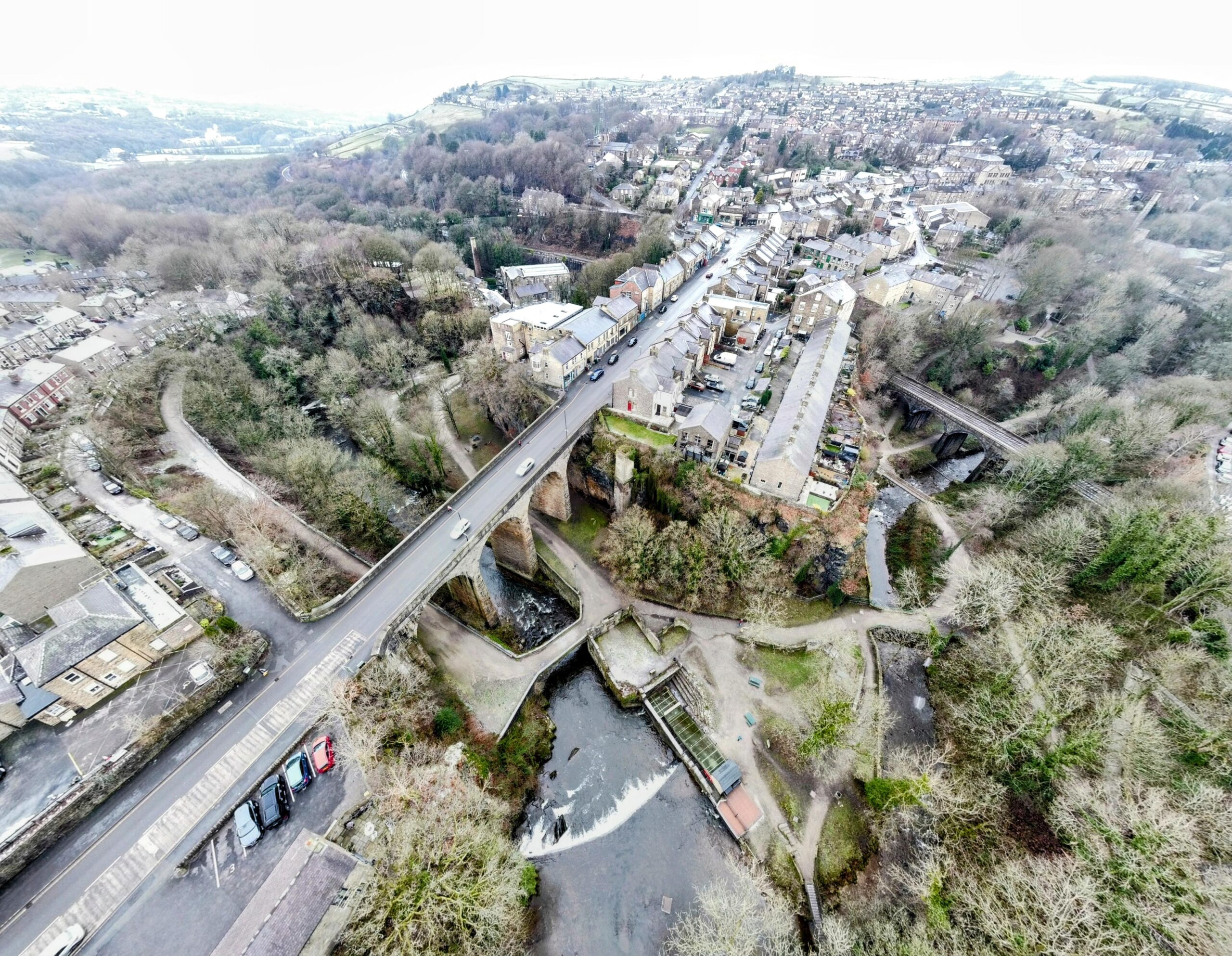
3. Bridges of New Mills
One of the places that most surprised me during this trip was New Mills.
As a schoolboy growing up near Manchester, New Mills had something of a fearsome reputation. Although it lay only eight miles from my home, it seemed a world away. Like many places viewed through the eyes of teenage boys, it acquired a mythology all of its own. Stories circulated about tough locals and generations of intermarriage. Whenever our school football team travelled to play New Mills, we half expected to return home with broken legs or black eyes. Looking back, of course, most of it was little more than schoolboy exaggeration.
Despite having known of the town all of my life, I had never properly explored it and therefore never fully appreciated its remarkable setting.
During this visit, my brother offered to take my wife and me on a circular walk around the town to see some of its attractions. Apart from playing a long-forgotten school football match there and travelling through New Mills Central railway station, all I really knew New Mills for came from friends who left school during the sixth form in the late 1970s to work at the Swizzels sweet factory so they could earn enough money to attend music concerts.

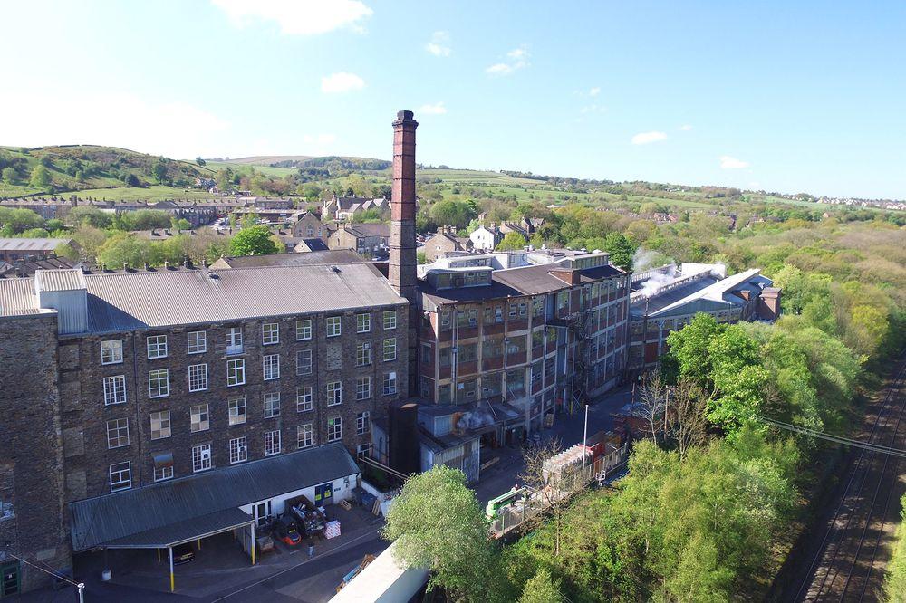
Many readers may already be familiar with Swizzels products without realising where they are made. Love Hearts, Drumsticks, Parma Violets, Refreshers, Double Dip and Squashies all originate from Swizzels Matlow Ltd, one of New Mills’ best-known employers and one of Britain’s most recognisable confectionery manufacturers.
Our walk took us through Torrs Riverside Park and along the spectacular Millennium Walkway before climbing back up to the Peak Forest Canal. We passed New Mills Marina, with its moored narrowboats, and continued past the Swizzels factory, where the air was filled with the wonderful aroma of raspberry-flavoured sweets. From there we returned through the River Goyt valley and back into the town for a cold cider in the Torr Vale Tap bar. On a glorious June afternoon, it proved to be one of the highlights of the trip.
New Mills itself is a small town in Derbyshire’s High Peak district, situated on the north-western edge of the Peak District National Park. Located approximately eight miles south-east of Stockport and thirteen miles from Manchester, it is not somewhere that immediately springs to mind when visitors think of northern England, yet it has one of the most remarkable industrial landscapes in the region.
What makes New Mills unique is its geography. The town is built around a dramatic sandstone gorge known as The Torrs, where the Rivers Goyt and Sett converge. Deep below the town centre, bridges, viaducts, roads, railways and former mill buildings crowd together within a spectacular valley that has shaped the town’s development for more than two centuries.
As we explored the gorge, what struck me was not simply the number of bridges, but the way each represented a different chapter in Britain’s transport history. Within a relatively compact area, one can see structures from the canal age, the railway age, the Victorian road-building era and the modern age existing side by side.
The steep-sided valley provided ideal locations for water-powered cotton mills, and by the early nineteenth century several mills were operating along the rivers. Their remains are still visible today, the most notable survivor being Torr Vale Mill, one of Britain’s longest-running textile mills.
New Mills is often described as “the town of bridges“, and once you understand its geography the reason becomes obvious. The Torrs gorge, approximately thirty metres deep, created a formidable barrier to movement. As the town expanded during the Industrial Revolution, engineers were repeatedly forced to devise new ways of crossing it. The result is a remarkable collection of bridges, viaducts and walkways that not only connected different parts of the town but also contributed significantly to its economic development.
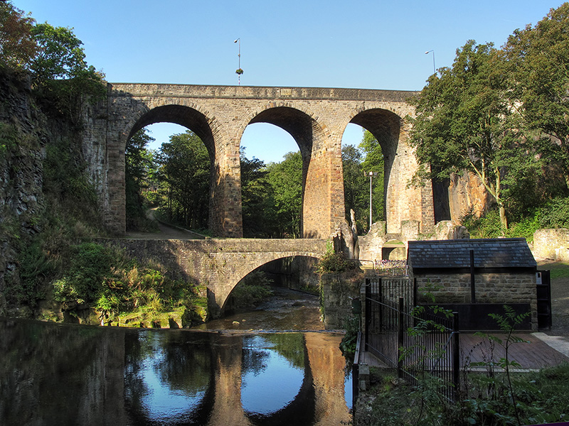
1. Union Road Bridge (1884)
The most striking bridge in New Mills, and usually the first to catch a visitor’s attention, is Union Road Bridge, completed in 1884.
Carrying Union Road high above the Torrs gorge, the bridge linked the original settlement of New Mills with Newtown on the opposite side of the valley. Before its construction, residents faced an inconvenient journey down steep roads into the gorge, across the river at a lower level, and then back up the other side. The new bridge transformed local communications and effectively united what had previously been two separate communities.
Standing approximately 29 metres above the River Goyt, Union Road Bridge offers some of the finest views in the town. From its parapets, visitors can look down into the dramatic gorge below, taking in the rivers, mills, railway structures and wooded valley that together create New Mills’ distinctive character.
Its alternative name, Union Bridge, neatly reflects its historical significance. More than simply a road crossing, it helped bring together two communities and contributed to the growth of a more integrated town.
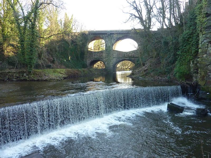
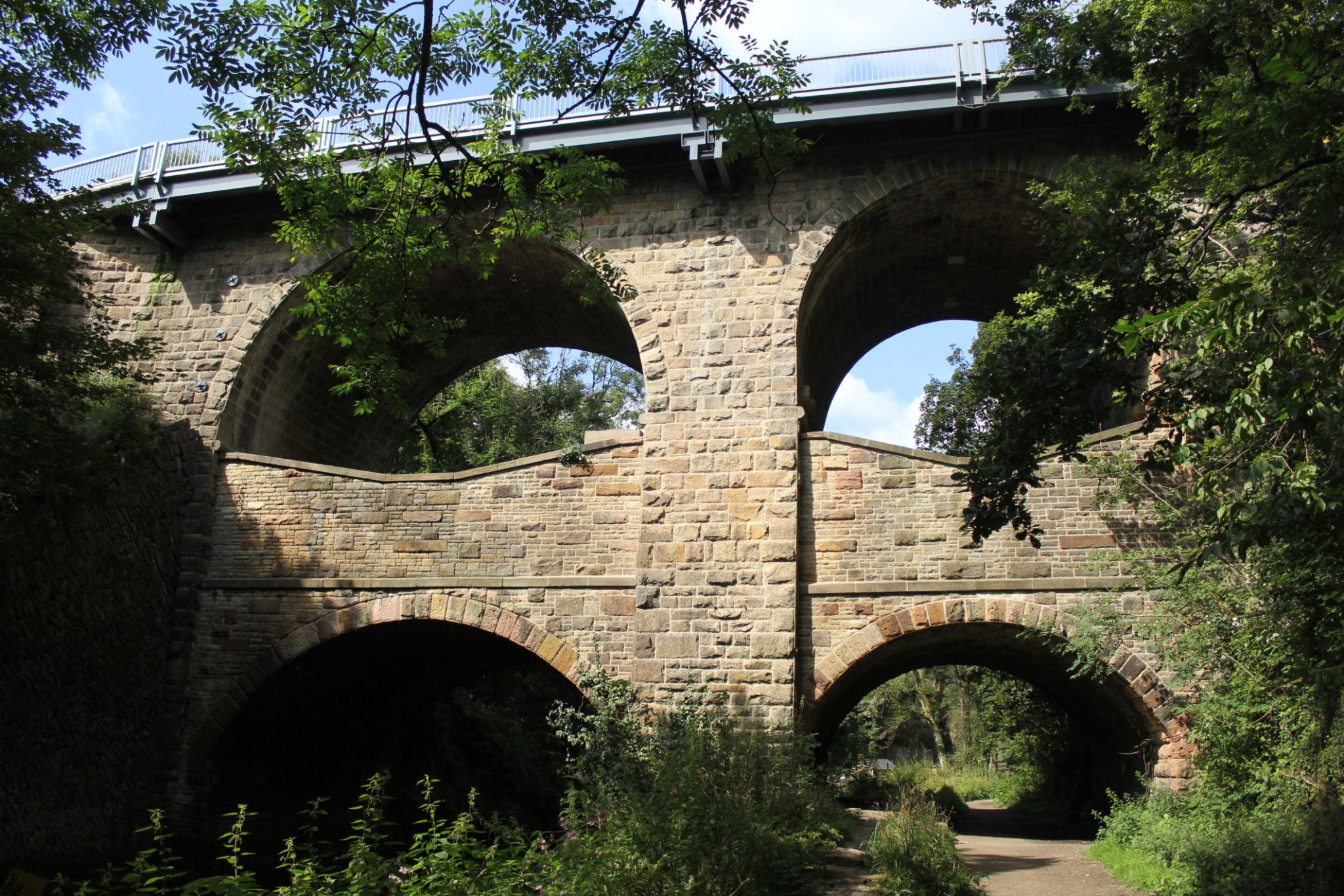
2. Church Road Bridge (1835)
Long before Union Road Bridge was constructed, the principal crossing of the gorge was Church Road Bridge, which opened in 1835.
Built by the local turnpike trust, the bridge was designed to improve communications across the valley and quickly became the town’s most important crossing. For almost fifty years it carried the majority of traffic moving between different parts of New Mills.
Church Road Bridge is particularly distinctive because of its unusual appearance. The large upper arches form the original 1835 structure, while a second series of smaller arches and buttresses was added in 1888 to strengthen the bridge and accommodate increasing traffic loads.
The result is a structure that appears almost double-decked, giving it a unique appearance among Victorian road bridges. It also provides a visible reminder of how infrastructure often evolves over time, with successive generations adapting existing structures to meet changing demands.
3. The Railway Viaducts
Victorian railway engineers faced precisely the same challenge as the road builders: how to cross a deep and rugged gorge while maintaining practical gradients for trains.
Their solution was a series of impressive railway viaducts that remain among the most dramatic features of the New Mills landscape.
The town was served by two railway routes, reflecting the intense competition between rival Victorian railway companies. One line ran towards Hayfield before eventually closing in 1970, while the other remains an important part of the route linking Manchester and Sheffield through the Pennine hills.
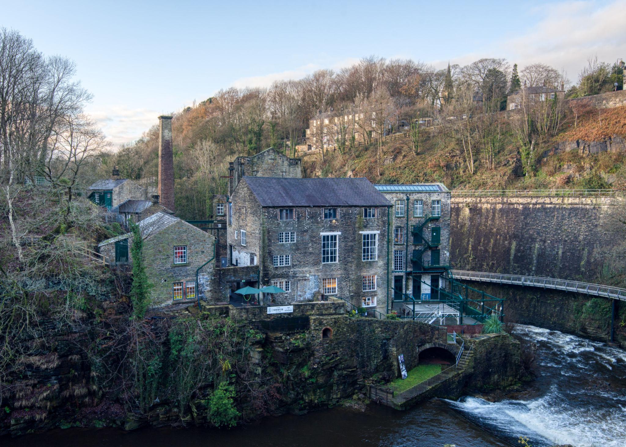
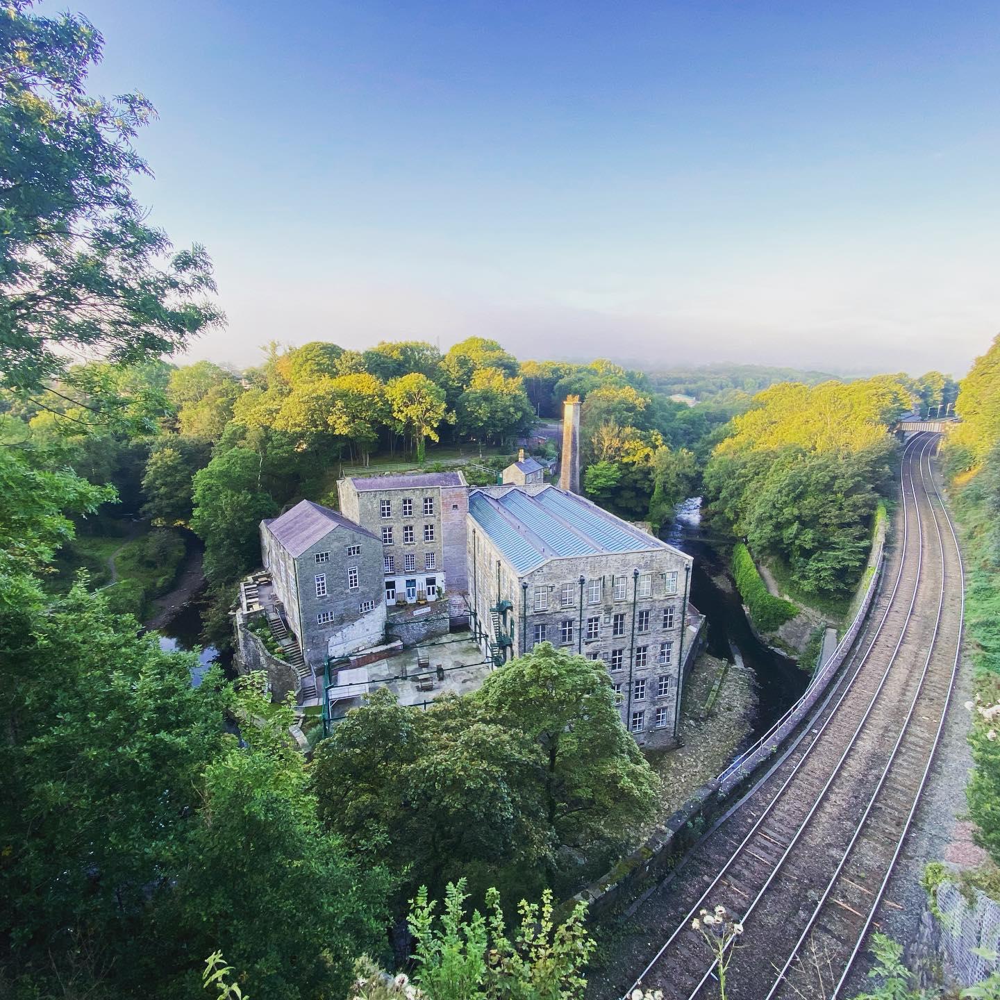
These viaducts were not isolated engineering achievements. Together with bridges, tunnels and embankments, they formed part of a wider transport network that enabled railways to overcome the natural barrier created by the Torrs gorge.
Alongside Church Road Bridge and Union Road Bridge, the railway structures played a crucial role in transforming New Mills from a collection of separate settlements into a fully connected industrial town. They allowed people, goods and raw materials to move more efficiently and helped integrate New Mills into the wider economy of northern England.
Today, as trains continue to cross the valley, the viaducts remain powerful reminders of the ambition and ingenuity of Victorian engineers.
4. The Low-Level Bridges
Long before the high-level bridges and railway viaducts dominated the skyline, movement across the rivers depended upon a network of much more modest crossings within the gorge itself.
Several low-level bridges were built during the late eighteenth and early nineteenth centuries to serve the cotton mills clustered along the riverbanks. These crossings carried workers, horses, carts and raw materials between the mills and the settlements above.
Although they are easily overlooked today, these bridges may be the most historically significant crossings in New Mills. They represent the original transport links that supported the town’s industrial development and provided the infrastructure upon which later growth depended.
Without these humble structures, the mills that drove the local economy could not have functioned effectively. In many ways, they laid the foundations for the more ambitious engineering projects that followed.
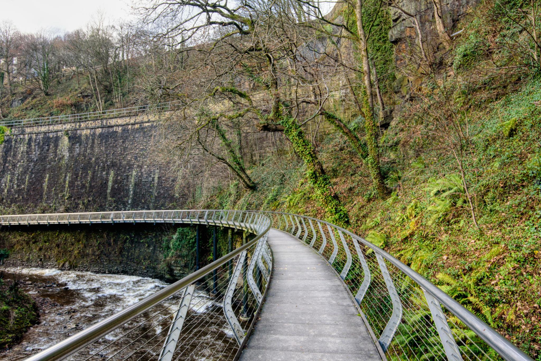
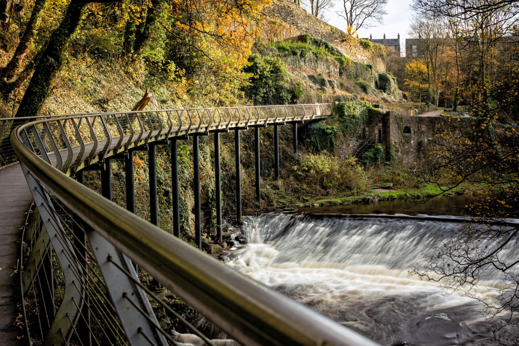
5. The Millennium Walkway (1999)
The newest and perhaps most distinctive crossing in New Mills is the Millennium Walkway.
Opened in 1999, this remarkable steel structure was created to provide a continuous pedestrian route through a section of the gorge that had previously been inaccessible.
Unlike a conventional bridge, the walkway is cantilevered directly from the sandstone cliff face above the River Goyt. Stretching for approximately 175 metres through the heart of the Torrs, it clings dramatically to the rock face while offering visitors an entirely new perspective on the landscape.
Viewed from below, the structure appears almost to float above the river. Its intricate steel framework has prompted many visitors to compare it to a giant spider’s web attached to the cliff.
The walkway quickly became one of Derbyshire’s most recognisable landmarks and has won widespread praise for both its engineering and architectural design.
More importantly, it allows visitors to experience the gorge from within rather than simply looking down upon it from above. Walking along the route provides close-up views of the rivers, mills, bridges and viaducts that define New Mills’ unique character and history.
Why New Mills Has So Many Bridges
The extraordinary concentration of bridges in New Mills can be traced to three key factors.
First, there is the deep Torrs gorge itself, which created a major obstacle to movement and transport.
Second, the town sits at the confluence of the Rivers Goyt and Sett, further complicating travel and communications.
Third, the Industrial Revolution created an urgent need for roads, railways and industrial transport routes capable of crossing the valley efficiently.
In many places, bridges are simply practical structures. In New Mills they played a far more significant role. Without them, the mills could not have expanded, the railways could not have crossed the valley, and Newtown and New Mills might have remained separate communities.
Today, few places in Britain offer such a concentrated collection of bridges, viaducts, walkways and industrial structures within such a dramatic natural setting. Together they tell the story of how successive generations of engineers overcame geographical challenges and, in doing so, helped create one of the most fascinating small towns in the Peak District.
Final Thoughts
One of the things that struck me most during this visit to Greater Manchester and neighbouring Derbyshire was the extent to which history remains woven into everyday life.
Historic structures are not preserved solely as museum exhibits or tourist attractions. Many continue to perform the functions for which they were originally built. Trains still cross Victorian viaducts. Boats still navigate canal aqueducts. Roads still follow routes established centuries ago. Even Hadrian’s Wall, approaching its second millennium, continues to shape the landscape and capture the imagination of those who visit it.
For those of us involved in construction and engineering, there is perhaps an additional lesson to be drawn from these structures.
The projects discussed in this article were conceived to solve practical problems: moving people, goods and raw materials more efficiently. Yet many have survived economic upheaval, technological change, wars, floods and the relentless passage of time. More remarkably, they continue to serve the communities for which they were built.
Perhaps nowhere illustrates this better than New Mills, where canal-age engineering, Victorian railways, historic road bridges and the modern Millennium Walkway coexist within a single dramatic gorge. Together they tell the story of how successive generations responded to the challenges of geography and transport, helping to shape the towns and industries that followed.
Standing beside some of these structures today—still carrying boats, trains, vehicles and pedestrians after 150, 200 or even 1,900 years—it is difficult not to admire the vision, skill and craftsmanship of those who created them.
They remind us that the most successful projects are not necessarily the largest or the most expensive. Rather, they are those that continue to provide value long after their builders have gone, serving future generations in ways their creators could scarcely have imagined.
Google Translation:
การเปรียบเทียบแง่มุมบางประการของชีวิตชาวไทยกับชีวิตในสหราชอาณาจักร จากการเดินทางไปแมนเชสเตอร์เมื่อเร็วๆ นี้ (ตอนที่ 2)
หมายเหตุ: ตอนที่ 1 นำเสนอการเปรียบเทียบบางแง่มุมของชีวิตในสหราชอาณาจักรและประเทศไทย ในขณะที่ตอนที่ 2 จะกล่าวถึงเฉพาะจุดที่น่าสนใจในการเดินทาง คือ สะพานประวัติศาสตร์ในท้องถิ่น
บทนำ
ดังที่ผมได้อธิบายไว้ในตอนที่ 1 ผมและภรรยาได้ใช้เวลาเกือบสองสัปดาห์ไปเยี่ยมครอบครัวที่แมนเชสเตอร์เมื่อเร็วๆ นี้
สิ่งแรกๆ ที่ทำให้ทุกคนที่มาเยือนสหราชอาณาจักร—ไม่ว่าจะเป็นนักท่องเที่ยวหรือชาวต่างชาติที่กลับบ้าน—ประทับใจก็คือประวัติศาสตร์อันยาวนานที่รายล้อมชีวิตประจำวัน อาคารเก่าแก่มีอยู่ทุกหนทุกแห่ง บ้านเรือน ฟาร์ม โบสถ์ ผับ สะพาน และโครงสร้างอุตสาหกรรมที่ตั้งตระหง่านมานานหลายศตวรรษยังคงเป็นส่วนหนึ่งของภูมิทัศน์สมัยใหม่ หลายแห่งมีอายุย้อนหลังไปหลายร้อยปี บางแห่งอยู่รอดมาได้เกือบสองพันปี
ตัวอย่างที่สมบูรณ์แบบคือ กำแพงฮาดริอันในนอร์ธัมเบอร์แลนด์ สร้างขึ้นตามคำสั่งของจักรพรรดิโรมันฮาดริอัน เริ่มต้นในปี ค.ศ. 122 ในฐานะพรมแดนทางตะวันตกเฉียงเหนือของจักรวรรดิโรมัน ทอดยาว 73 ไมล์ (117 กิโลเมตร) จากแม่น้ำไทน์ทางตะวันออกไปยังอ่าวโซลเวย์ทางตะวันตกของอังกฤษตอนเหนือ กำแพงแห่งนี้ใช้เวลาสร้างประมาณหกปี รวมทั้งป้อมปราการ ป้อมย่อย หอสังเกตการณ์ และคูเมืองป้องกัน ที่น่าทึ่งคือ ส่วนสำคัญหลายส่วนยังคงหลงเหลืออยู่จนถึงทุกวันนี้ ในปี 2026 กำแพงแห่งนี้มีอายุมากกว่า 1,900 ปีแล้ว แต่ก็ยังคงเป็นหนึ่งในอนุสรณ์สถานทางประวัติศาสตร์ที่น่าประทับใจที่สุดของสหราชอาณาจักร
กำแพงฮาดริอัน
ตัวอย่างของความต่อเนื่องกับอดีตนี้สามารถพบได้เกือบทุกที่ ในหมู่บ้านของฉันเอง อาคารที่เก่าแก่ที่สุดที่ยังหลงเหลืออยู่มีอายุตั้งแต่ก่อนปี 1347 บ้านและฟาร์มจำนวนมากถูกสร้างขึ้นในช่วงศตวรรษที่สิบหก ในขณะที่ผับที่เก่าแก่ที่สุดที่ยังคงเปิดให้บริการอยู่ถูกสร้างขึ้นในปี 1722 และมีแผ่นหินสลักวันที่ “TCH 1722” อยู่เหนือทางเข้าอย่างภาคภูมิใจ ทั้งหมดนี้ไม่ได้ผิดปกติอะไรนักเมื่อเทียบกับมาตรฐานของอังกฤษ ตัวอย่างที่คล้ายกันนี้สามารถพบได้ในหมู่บ้านต่างๆ ทั่วประเทศ
เพื่อให้เห็นภาพชัดเจนขึ้น อาคารบางแห่งในหมู่บ้านของผมสร้างขึ้นก่อนที่ชาวพิลกริมจะล่องเรือเมย์ฟลาวเวอร์ออกจากพลีมัธในปี 1620 และนานก่อนที่กัปตันเจมส์ คุกจะสำรวจนิวซีแลนด์และชายฝั่งตะวันออกของออสเตรเลีย
อย่างไรก็ตาม ในการเดินทางกลับบ้านครั้งล่าสุดนี้ สิ่งที่ดึงดูดความสนใจของผมเป็นพิเศษไม่ใช่บ้านหรือโบสถ์โบราณ แต่เป็นสะพานต่างๆ
สหราชอาณาจักรมีสะพาน สะพานลอย และท่อส่งน้ำโบราณที่น่าทึ่งมากมาย ซึ่งหลายแห่งยังคงทำหน้าที่ตามวัตถุประสงค์ดั้งเดิมที่สร้างขึ้น สำหรับผู้ที่เกี่ยวข้องกับการก่อสร้าง วิศวกรรม สัญญา หรือการบริหารโครงการ โครงสร้างเหล่านี้เป็นตัวอย่างที่น่าสนใจของโครงการที่ยืนหยัดผ่านกาลเวลา
สะพานลอยสต็อกพอร์ต
1. สะพานลอยสต็อกพอร์ต
บางทีสะพานที่มีชื่อเสียงที่สุดในพื้นที่ของผมคือสะพานลอยสต็อกพอร์ต ซึ่งเป็นโครงสร้างที่ได้รับการขึ้นทะเบียนเป็นมรดกทางสถาปัตยกรรมระดับ 2 สร้างเสร็จในปี 1840 ทอดยาว 550 เมตรข้ามหุบเขาแม่น้ำเมอร์ซีย์และสูงขึ้น 34 เมตรเหนือแม่น้ำเมอร์ซีย์เบื้องล่าง ยังคงเป็นหนึ่งในสะพานลอยทางรถไฟอิฐที่ใหญ่ที่สุดในสหราชอาณาจักร
ภรรยาของผมเดินทางไปเกรทเทอร์แมนเชสเตอร์กับผมเกือบสามสิบปีแล้ว และได้เห็นสถานที่ท่องเที่ยวสำคัญๆ ส่วนใหญ่ของที่นี่แล้ว แต่มีที่หนึ่งที่หลุดรอดจากแผนการเดินทางของเราไปจนกระทั่งทริปนี้ นั่นคือ โรงงานผลิตหมวก (Hat Works) ในสต็อกพอร์ต พิพิธภัณฑ์แห่งเดียวในสหราชอาณาจักรที่อุทิศให้กับอุตสาหกรรมการผลิตหมวกโดยเฉพาะ
เมื่อมองแวบแรก ความเชื่อมโยงระหว่างสต็อกพอร์ตกับหมวกอาจดูน่าประหลาดใจ แต่ตลอดช่วงศตวรรษที่สิบเก้าและต้นศตวรรษที่ยี่สิบ สต็อกพอร์ตเป็นหนึ่งในศูนย์กลางการผลิตหมวกที่สำคัญที่สุดของโลก และเป็นเมืองหลวงที่ไม่มีใครโต้แย้งได้ของอุตสาหกรรมหมวกสักหลาดของอังกฤษ
ในช่วงที่รุ่งเรืองที่สุด:
มีโรงงานผลิตหมวกมากกว่า 100 แห่งในและรอบๆ เมือง
มีผู้คนหลายพันคนทำงานในอุตสาหกรรมนี้
มีการผลิตหมวกหลายล้านใบในแต่ละปี
หมวกสักหลาดจำนวนมากของอังกฤษผลิตในสต็อกพอร์ต
หมวกที่ผลิตในสต็อกพอร์ตถูกส่งออกไปทั่วโลก
ภาพที่แขวนอยู่ใน Hat Works – คุณเห็นคนที่ไม่สวมหมวกหรือไม่?
โรงงานผลิตหมวกสต็อกพอร์ต
เมืองนี้มีชื่อเสียงเป็นพิเศษในการผลิตหมวกสักหลาดสำหรับผู้ชาย รวมถึงหมวกทรงโบว์เลอร์ หมวกทรงสูง และหมวกเฟโดรา
อย่างไรก็ตาม เช่นเดียวกับอุตสาหกรรมดั้งเดิมหลายแห่ง การค้าขายก็เสื่อมถอยลงหลังจากทศวรรษ 1950 เนื่องจากแฟชั่นการสวมหมวกค่อยๆ หมดความนิยม ความต้องการลดลง โรงงานปิดตัวลง การจ้างงานลดลง และการผลิตย้ายไปต่างประเทศมากขึ้นเรื่อยๆ จนกระทั่งสิ้นศตวรรษที่ 20 โรงงานผลิตหมวกที่มีชื่อเสียงของสต็อกพอร์ตส่วนใหญ่ก็หายไป
ปัจจุบัน พิพิธภัณฑ์โรงงานผลิตหมวก ซึ่งตั้งอยู่ในโรงงานผลิตหมวกสมัยวิคตอเรียนเก่า เป็นหนึ่งในสิ่งเตือนใจที่ดีที่สุดเกี่ยวกับมรดกทางอุตสาหกรรมที่สำคัญนี้
สะพานลอยสต็อกพอร์ต
สะพานลอยสต็อกพอร์ตพร้อมทางหลวง M60 อยู่ด้านล่าง
สะพานลอยตั้งตระหง่านอยู่เหนือทั้งพิพิธภัณฑ์และใจกลางเมืองสต็อกพอร์ต
การก่อสร้างสะพานลอยสต็อกพอร์ตเริ่มต้นในเดือนมีนาคม ค.ศ. 1839 และเสร็จสมบูรณ์เพียง 21 เดือนต่อมาในเดือนธันวาคม ค.ศ. 1840 เมื่อพิจารณาถึงขนาดของโครงการและความท้าทายในการก่อสร้างสูงเหนือหุบเขาแม่น้ำเมอร์ซีย์ นี่จึงเป็นความสำเร็จที่น่าทึ่ง
โรงแรมคราวน์อินน์สมัยวิคตอเรียน เกือบอยู่ใต้สะพานรถไฟสต็อกพอร์ต
สะพานรถไฟสต็อกพอร์ต
แม่น้ำเมอร์ซีย์ ซึ่งเชื่อมต่อกับเมืองลิเวอร์พูลมาโดยตลอดนั้น แท้จริงแล้วเริ่มต้นจากจุดบรรจบกันของแม่น้ำกอยต์และแม่น้ำเทมในสต็อกพอร์ต ซึ่งอยู่ห่างจากสะพานรถไฟสต็อกพอร์ตเพียงไม่กี่ก้าว
เมื่อสร้างเสร็จ สะพานรถไฟสต็อกพอร์ตได้รับการกล่าวขานว่าเป็นสะพานรถไฟที่ใหญ่ที่สุดในโลก เป็นหนึ่งในโครงสร้างอิฐที่ใหญ่ที่สุดเท่าที่เคยสร้างมา และเป็นหนึ่งในความสำเร็จทางวิศวกรรมที่ยิ่งใหญ่ที่สุดในยุคแรกของการรถไฟ มีคนงานประมาณ 600 คนทำงานในการก่อสร้าง โดยใช้อิฐมากถึง 11 ล้านก้อน
โครงสร้างประกอบด้วยซุ้มโค้งครึ่งวงกลม 22 ซุ้ม แต่ละซุ้มกว้าง 19.2 เมตร ซุ้มเหล่านี้ได้รับการรองรับโดยเสาอิฐสีแดงขนาดใหญ่หนา 3 เมตร ในขณะที่ซุ้มโค้งขนาดเล็กกว่าที่ปลายทั้งสองข้างช่วยเพิ่มความมั่นคง เดิมสร้างขึ้นเพื่อรองรับรางรถไฟสองราง แต่สะพานรถไฟได้ขยายให้กว้างขึ้นในช่วงปลายทศวรรษ 1880 เพื่อรองรับรางรถไฟสี่รางเนื่องจากการจราจรทางรถไฟเพิ่มขึ้น
สะพานลอยแห่งนี้เป็นส่วนสำคัญของเส้นทางรถไฟแมนเชสเตอร์-สต็อกพอร์ต ซึ่งเปิดให้บริการในเดือนมิถุนายน ปี 1840 ต่อมาในปี 1842 ได้มีการเปิดบริการรถไฟตรงไปยังครูว์และลอนดอน ซึ่งช่วยสร้างเส้นทางคมนาคมที่สำคัญที่สุดแห่งหนึ่งของสหราชอาณาจักร
เกือบสองศตวรรษต่อมา สะพานลอยแห่งนี้ยังคงเป็นส่วนประกอบสำคัญของเครือข่ายรถไฟแห่งชาติ มีรถไฟเกือบ 400 ขบวนวิ่งผ่านทุกวันในเส้นทางรถไฟสายหลักชายฝั่งตะวันตก
สิ่งที่ทำให้สะพานลอยสต็อกพอร์ตน่าประทับใจเป็นพิเศษ ไม่ใช่เพียงแค่ขนาดของมัน แต่ยังรวมถึงความยืนยาว หลังจากเกือบ 187 ปี มันยังคงทำหน้าที่ตามที่ออกแบบไว้ได้อย่างแม่นยำ มันเป็นเครื่องเตือนใจที่ทรงพลังถึงความทะเยอทะยาน ความมั่นใจ และความเป็นเลิศทางวิศวกรรมของยุควิกตอเรีย
2. สะพานส่งน้ำมาร์เปิลและสะพานลอยมาร์เปิล
ถึงแม้ว่าสะพานลอยสต็อกพอร์ตอาจเป็นสะพานที่มีชื่อเสียงที่สุดในพื้นที่ของฉัน แต่สะพานที่ฉันชื่นชอบที่สุดก็คือสะพานส่งน้ำมาร์เปิลอย่างไม่ต้องสงสัย
ทุกครั้งที่ผมกับภรรยากลับบ้าน การเดินเล่นที่มักจะอยู่ในแผนการเดินทางของเราเสมอคือช่วงที่สวยงามของคลองพีคฟอเรสต์ระหว่างมาร์เปิลและโรไมลีย์ เส้นทางนี้ผสมผสานชนบทที่สวยงามเข้ากับการมองเห็นอดีตอุตสาหกรรมของอังกฤษที่น่าสนใจ ระหว่างทางมีประตูน้ำคลอง 16 แห่งที่มีชื่อเสียงของมาร์เปิล สะพานส่งน้ำมาร์เปิลที่น่าประทับใจ และสะพานรถไฟมาร์เปิลที่อยู่ใกล้เคียงกัน
สะพานส่งน้ำสร้างเสร็จในปี 1800 เป็นส่วนหนึ่งของคลองพีคฟอเรสต์ ออกแบบโดยเบนจามิน เอาต์แรม หนึ่งในวิศวกรคลองชั้นนำของการปฏิวัติอุตสาหกรรม การก่อสร้างเริ่มขึ้นในปี 1795 ซุ้มโค้งสร้างเสร็จในปี 1799 และในปี 1800 เรือคลองก็เริ่มแล่นผ่านเหนือแม่น้ำกอยต์แล้ว
เพื่อให้เข้าใจถึงความสำคัญของสะพานส่งน้ำ จำเป็นต้องเข้าใจวัตถุประสงค์ของคลองนั้นเอง
ในช่วงปลายศตวรรษที่สิบแปด แมนเชสเตอร์กำลังขยายตัวอย่างรวดเร็ว โรงงานใหม่ โรงสี ถนน และโครงการพัฒนาที่อยู่อาศัยต่างต้องการหินปูน ปูนขาวสำหรับทำปูนฉาบและการเกษตร ถ่านหิน และวัตถุดิบอื่น ๆ ในปริมาณมหาศาล เขตพีคดิสทริกต์รอบ ๆ บักซ์ตันและคาสเซิลตันมีแหล่งหินปูนอุดมสมบูรณ์ แต่การขนส่งวัสดุหนักเช่นนี้ด้วยม้าและเกวียนนั้นช้า ยากลำบาก และมีราคาแพง คลองจึงเป็นทางออกที่มีประสิทธิภาพมากกว่ามาก
สะพานส่งน้ำมาร์เปิลพร้อมแม่น้ำกอยต์ด้านล่าง
คลองพีคฟอเรสต์ได้รับการอนุมัติจากรัฐสภาในปี 1794 และก่อสร้างระหว่างปี 1795 ถึง 1800 จุดประสงค์หลักคือการขนส่งหินปูน ปูนขาว และแร่ธาตุอื่น ๆ จากเขตพีคดิสทริกต์ไปยังแมนเชสเตอร์และชุมชนอุตสาหกรรมที่กำลังเติบโตตามเส้นทาง
ความท้าทายที่ยิ่งใหญ่ที่สุดที่วิศวกรของคลองต้องเผชิญคือหุบเขาลึกของแม่น้ำกอยต์ที่มาร์เปิล
แทนที่จะบังคับให้เรือลงไปในหุบเขาแล้วปีนกลับขึ้นมาผ่านชุดประตูน้ำที่ยาวเหยียด เอาท์แรมเสนอทางออกที่กล้าหาญ สะพานส่งน้ำของเขาจะยกระดับคลองให้สูงกว่าแม่น้ำประมาณสามสิบเมตร ทำให้เรือสามารถแล่นไปตามเส้นทางที่เกือบจะราบเรียบได้ ช่วยประหยัดเวลาและค่าใช้จ่ายได้อย่างมาก
กว่าสองศตวรรษต่อมา สะพานส่งน้ำมาร์เปิลยังคงเป็นสะพานส่งน้ำคลองที่สูงที่สุดในอังกฤษ เป็นทั้งสิ่งก่อสร้างที่ได้รับการขึ้นทะเบียนเป็นมรดกทางอุตสาหกรรมระดับ 1 และเป็นอนุสรณ์สถานทางประวัติศาสตร์ สะท้อนให้เห็นถึงความสำคัญในฐานะหนึ่งในแหล่งมรดกทางอุตสาหกรรมที่สำคัญที่สุดของสหราชอาณาจักร
ขนาดของโครงสร้างนั้นน่าประทับใจแม้ในมาตรฐานสมัยใหม่ มีความยาว 94 เมตร และประกอบด้วยวัสดุก่อสร้างประมาณ 6,000 ลูกบาศก์เมตร รองรับด้วยซุ้มโค้งครึ่งวงกลมขนาดใหญ่สามแห่งที่ทอดข้ามหุบเขาเบื้องล่าง การยืนอยู่บนทางเดินริมคลองและมองลงไปยังแม่น้ำกอยต์ที่อยู่ด้านล่างประมาณสามสิบเมตร ยังคงเป็นประสบการณ์ที่น่าหวาดเสียวเล็กน้อย
สะพานส่งน้ำมาร์เปิลพร้อมสะพานลอยด้านหลัง มองจากด้านบน
สะพานส่งน้ำมาร์เปิลพร้อมสะพานลอยด้านหลัง มองจากด้านบน 2
ในอดีต สะพานส่งน้ำคลองมักถูกออกแบบโดยมีกำแพงป้องกันด้านทางเดินริมคลอง แต่มีกำแพงป้องกันน้อยหรือไม่มีเลยด้านที่ติดกับคลอง สะพานส่งน้ำมาร์เปิลถูกสร้างขึ้นโดยไม่มีรั้วกั้นด้านข้าง เด็กหนุ่มในท้องถิ่นจึงเกิดประเพณีท้าทายกันให้กระโดดข้ามคลองจากฝั่งทางเดินริมคลองไปยังอีกฝั่งที่ไม่มีรั้วกั้น ซึ่งเป็นสิ่งที่ต้องใช้ความกล้าหาญมากกว่าสามัญสำนึกมาก
น่าเสียดายที่ในช่วงทศวรรษ 2010 เกิดอุบัติเหตุร้ายแรงหลายครั้ง เมื่อมีคนพลัดตกลงมาจากสะพานส่งน้ำลงสู่หุบเขาเบื้องล่าง เพื่อเป็นการตอบสนอง หน่วยงาน Canal & River Trust จึงได้ว่าจ้างให้ติดตั้งราวเหล็กกั้นด้านข้างคลองที่ออกแบบมาอย่างพิถีพิถันในปี 2017 ราวกั้นใหม่นี้ช่วยเพิ่มความปลอดภัยอย่างมาก ในขณะเดียวกันก็ยังคงรักษารูปลักษณ์ทางประวัติศาสตร์ของโครงสร้างไว้
สะพานส่งน้ำมาร์เปิลที่ไม่มีราวกั้นด้านข้าง
สะพานส่งน้ำมาร์เปิลที่มีราวกั้นด้านข้าง
ข้างๆ สะพานส่งน้ำคือสะพานรถไฟมาร์เปิล ซึ่งสร้างเสร็จในปี 1863 สำหรับทางรถไฟแมนเชสเตอร์ เชฟฟิลด์ และลินคอล์นเชียร์
สะพานรถไฟมาร์เปิล
สะพานรถไฟมาร์เปิลโดยมีราวกั้นด้านข้างของสะพานส่งน้ำอยู่ด้านหน้า
เช่นเดียวกับสะพานส่งน้ำ สะพานรถไฟแห่งนี้ข้ามแม่น้ำกอยต์ที่ระดับความสูงมาก โครงสร้างที่ได้รับการขึ้นทะเบียนเป็นโบราณสถานระดับ 2 แห่งนี้สูงประมาณ 38 เมตรเหนือแม่น้ำ ประกอบด้วยซุ้มหิน 12 ซุ้ม และโครงเหล็กดัด กว่า 160 ปีหลังจากการสร้างเสร็จสมบูรณ์ สะพานแห่งนี้ยังคงให้บริการรถไฟระหว่างแมนเชสเตอร์ นิว มิลส์ และเชฟฟิลด์ (ซึ่งเป็นเส้นทางรถไฟคนละสายกับสะพานสต็อกพอร์ตที่รู้จักกันดีกว่า)
มีสถานที่เพียงไม่กี่แห่งที่แสดงให้เห็นถึงประวัติศาสตร์การขนส่งของอังกฤษได้อย่างมีประสิทธิภาพเท่ากับมาร์เปิล ภายในระยะไม่กี่เมตร มีสิ่งก่อสร้างทางวิศวกรรมที่สำคัญสองแห่งจากยุคสมัยที่แตกต่างกันตั้งอยู่: แห่งหนึ่งเป็นตัวแทนของยุคคลองอันยิ่งใหญ่ในปลายศตวรรษที่สิบแปด อีกแห่งหนึ่งเป็นสัญลักษณ์ของการปฏิวัติทางรถไฟในศตวรรษที่สิบเก้า แต่ละแห่งล้วนเป็นตัวแทนของเทคโนโลยีการขนส่งที่ล้ำสมัยในยุคนั้น และทั้งสองยังคงทำหน้าที่ตามวัตถุประสงค์ดั้งเดิมมานานหลายศตวรรษ
มาร์เปิลยังมีความเชื่อมโยงทางวรรณกรรมที่น่าสนใจอีกด้วย เป็นที่เชื่อกันอย่างกว้างขวางว่า อกาธา คริสตี ได้รับแรงบันดาลใจจากชื่อหมู่บ้านนี้เมื่อสร้างตัวละครนักสืบชื่อดังอย่าง มิส มาร์เปิล หนึ่งในตัวละครที่ยืนยงที่สุดในนิยายอาชญากรรมของอังกฤษ
นิว มิลส์
3. สะพานแห่งนิว มิลส์
หนึ่งในสถานที่ที่ทำให้ฉันประหลาดใจมากที่สุดระหว่างการเดินทางครั้งนี้คือ นิว มิลส์
สมัยที่ผมยังเป็นนักเรียนมัธยมปลาย ผมรู้จักนิว มิลส์ในฐานะเมืองที่มีชื่อเสียงในแง่ลบ แม้จะอยู่ห่างจากบ้านผมเพียงแปดไมล์ แต่ก็ดูเหมือนอยู่คนละโลก เหมือนกับหลายๆ ที่ที่เด็กวัยรุ่นมอง นิว มิลส์ก็มีตำนานเป็นของตัวเอง เรื่องราวต่างๆ เกี่ยวกับชาวบ้านที่แข็งกร้าวและการแต่งงานข้ามเผ่าพันธุ์เล่าขานกันมาหลายรุ่น ทุกครั้งที่ทีมฟุตบอลของโรงเรียนไปแข่งที่นิว มิลส์ เรามักคาดหวังว่าจะกลับบ้านพร้อมขาหักหรือตาบวม มองย้อนกลับไปแล้ว แน่นอนว่าส่วนใหญ่ก็เป็นเพียงการพูดเกินจริงของเด็กมัธยมปลายเท่านั้น
ถึงแม้จะรู้จักเมืองนี้มาตลอดชีวิต แต่ผมก็ไม่เคยสำรวจมันอย่างจริงจังและไม่เคยได้ชื่นชมความงดงามของสถานที่นี้อย่างเต็มที่
ในการมาเยือนครั้งนี้ พี่ชายของผมเสนอที่จะพาผมและภรรยาไปเดินเล่นรอบเมืองเพื่อชมสถานที่น่าสนใจต่างๆ นอกจากการเล่นฟุตบอลในโรงเรียนที่ลืมเลือนไปนานแล้ว และการเดินทางผ่านสถานีรถไฟนิว มิลส์ เซ็นทรัลแล้ว สิ่งที่ฉันรู้จักเกี่ยวกับนิว มิลส์จริงๆ ก็มาจากเพื่อนๆ ที่ออกจากโรงเรียนในช่วงมัธยมปลายปลายทศวรรษ 1970 เพื่อไปทำงานที่โรงงานผลิตขนมสวิซเซลส์ เพื่อหาเงินไปดูคอนเสิร์ต
ขนมสวิซเซลส์
โรงงานสวิซเซลส์
ผู้อ่านหลายท่านอาจคุ้นเคยกับผลิตภัณฑ์ของสวิซเซลส์อยู่แล้วโดยไม่รู้ว่าผลิตที่ไหน ขนมรูปหัวใจ ลูกอมดรัมสติ๊ก พาร์มาไวโอเล็ต รีเวิร์สเซอร์ส ดับเบิลดิป และสควอชชี่ ล้วนมาจากบริษัทสวิซเซลส์ แมทโลว์ จำกัด ซึ่งเป็นหนึ่งในนายจ้างที่รู้จักกันดีที่สุดในนิว มิลส์ และเป็นหนึ่งในผู้ผลิตขนมหวานที่รู้จักกันดีที่สุดของสหราชอาณาจักร
การเดินของเราพาเราผ่านสวนสาธารณะทอร์ส ริเวอร์ไซด์ และไปตามทางเดินมิลเลนเนียมอันงดงาม ก่อนที่จะปีนกลับขึ้นไปที่คลองพีคฟอเรสต์ เราผ่านท่าเรือนิว มิลส์ ที่มีเรือแคบจอดอยู่ และผ่านโรงงานสวิซเซลส์ ที่ซึ่งอากาศอบอวลไปด้วยกลิ่นหอมของลูกอมรสราสเบอร์รี่ จากนั้นเราก็กลับลงมาตามหุบเขาแม่น้ำกอยต์ และกลับเข้าเมืองเพื่อดื่มไซเดอร์เย็นๆ ที่บาร์ทอร์ เวล แทป ในช่วงบ่ายของเดือนมิถุนายนที่งดงามนั้น มันพิสูจน์แล้วว่าเป็นหนึ่งในไฮไลท์ของการเดินทาง
นิว มิลส์ เป็นเมืองเล็กๆ ในเขตไฮ พีค ของเดอร์บีเชอร์ ตั้งอยู่ทางขอบด้านตะวันตกเฉียงเหนือของอุทยานแห่งชาติพีค ดิสทริกต์ ตั้งอยู่ห่างจากสต็อกพอร์ตไปทางตะวันออกเฉียงใต้ประมาณ 8 ไมล์ และห่างจากแมนเชสเตอร์ 13 ไมล์ มันไม่ใช่สถานที่ที่นักท่องเที่ยวจะนึกถึงทันทีเมื่อพูดถึงภาคเหนือของอังกฤษ แต่ที่นี่มีภูมิทัศน์อุตสาหกรรมที่น่าทึ่งที่สุดแห่งหนึ่งในภูมิภาค
สิ่งที่ทำให้นิว มิลส์ มีเอกลักษณ์เฉพาะตัวคือภูมิศาสตร์ เมืองนี้สร้างขึ้นรอบๆ หุบเขาหินทรายที่งดงามตระการตาที่รู้จักกันในชื่อ เดอะ ทอร์ส ซึ่งเป็นจุดบรรจบกันของแม่น้ำกอยต์และแม่น้ำเซตต์ ลึกลงไปใต้ใจกลางเมือง สะพาน ทางยกระดับ ถนน ทางรถไฟ และอาคารโรงงานเก่าต่าง ๆ ต่างแออัดกันอยู่ในหุบเขาอันงดงามที่ได้หล่อหลอมการพัฒนาของเมืองมานานกว่าสองศตวรรษ
ขณะที่เราสำรวจหุบเขา สิ่งที่ทำให้ฉันประทับใจไม่ใช่แค่จำนวนสะพาน แต่เป็นวิธีที่แต่ละสะพานแสดงถึงบทบาทที่แตกต่างกันในประวัติศาสตร์การคมนาคมของอังกฤษ ในพื้นที่ที่ค่อนข้างกะทัดรัด เราสามารถเห็นโครงสร้างจากยุคคลอง ยุครถไฟ ยุคการสร้างถนนในสมัยวิกตอเรีย และยุคสมัยใหม่ตั้งอยู่เคียงข้างกัน
หุบเขาที่มีหน้าผาสูงชันเป็นสถานที่ที่เหมาะสมสำหรับโรงงานปั่นฝ้ายที่ใช้พลังงานน้ำ และในช่วงต้นศตวรรษที่สิบเก้า โรงงานหลายแห่งได้ดำเนินการอยู่ตามริมแม่น้ำ ซากของโรงงานเหล่านั้นยังคงมองเห็นได้ในปัจจุบัน โรงงานที่โดดเด่นที่สุดคือโรงงาน Torr Vale Mill ซึ่งเป็นหนึ่งในโรงงานทอผ้าที่ดำเนินกิจการมายาวนานที่สุดของอังกฤษ
เมืองนิว มิลส์ มักถูกอธิบายว่าเป็น “เมืองแห่งสะพาน” และเมื่อคุณเข้าใจภูมิศาสตร์ของมันแล้ว เหตุผลก็จะชัดเจน หุบเขาทอร์ส ซึ่งมีความลึกประมาณสามสิบเมตร สร้างอุปสรรคสำคัญต่อการสัญจร เมื่อเมืองขยายตัวในช่วงการปฏิวัติอุตสาหกรรม วิศวกรจึงถูกบังคับให้คิดค้นวิธีการข้ามหุบเขาแบบใหม่ๆ อยู่เสมอ ผลลัพธ์ที่ได้คือกลุ่มสะพาน สะพานลอย และทางเดินเท้าที่น่าทึ่ง ซึ่งไม่เพียงแต่เชื่อมต่อส่วนต่างๆ ของเมืองเท่านั้น แต่ยังช่วยส่งเสริมการพัฒนาเศรษฐกิจอย่างมีนัยสำคัญอีกด้วย
สะพานยูเนียนและสะพานสำหรับม้าบรรทุกสัมภาระที่ถูกแทนที่
1. สะพานยูเนียนโรด (1884)
สะพานที่โดดเด่นที่สุดในนิว มิลส์ และมักจะเป็นสิ่งแรกที่ดึงดูดความสนใจของผู้มาเยือน คือ สะพานยูเนียนโรด ซึ่งสร้างเสร็จในปี 1884
สะพานนี้ทอดข้ามถนนยูเนียนโรดสูงเหนือหุบเขาทอร์ส เชื่อมต่อชุมชนดั้งเดิมของนิว มิลส์ กับเมืองนิวทาวน์ที่อยู่ฝั่งตรงข้ามของหุบเขา ก่อนการสร้างสะพาน ชาวบ้านต้องเดินทางอย่างไม่สะดวกสบายลงไปตามถนนที่ลาดชันลงไปในหุบเขา ข้ามแม่น้ำในระดับที่ต่ำกว่า แล้วกลับขึ้นมาอีกฝั่ง สะพานใหม่นี้ได้เปลี่ยนแปลงการคมนาคมในท้องถิ่นและรวมสิ่งที่เคยเป็นสองชุมชนที่แยกจากกันเข้าด้วยกันอย่างมีประสิทธิภาพ
สะพานยูเนียนโรดตั้งอยู่สูงประมาณ 29 เมตรเหนือแม่น้ำกอยต์ มอบทัศนียภาพที่สวยงามที่สุดแห่งหนึ่งในเมือง จากกำแพงสะพาน นักท่องเที่ยวสามารถมองลงไปยังหุบเขาอันงดงามเบื้องล่าง มองเห็นแม่น้ำ โรงสี โครงสร้างทางรถไฟ และหุบเขาที่มีป่าไม้ ซึ่งทั้งหมดนี้รวมกันสร้างเอกลักษณ์เฉพาะตัวของเมืองนิว มิลส์
ชื่อเรียกอีกชื่อหนึ่งของสะพานแห่งนี้คือ สะพานยูเนียน (Union Bridge) ซึ่งสะท้อนถึงความสำคัญทางประวัติศาสตร์ได้อย่างลงตัว มากกว่าแค่ทางข้ามถนน สะพานแห่งนี้ช่วยเชื่อมโยงสองชุมชนเข้าด้วยกันและส่งเสริมการเติบโตของเมืองที่ผสานรวมเป็นหนึ่งเดียวมากขึ้น
สะพานเชิร์ชโรด (Church Road Bridge)
สะพานเชิร์ชโรด
2. สะพานเชิร์ชโรด (ค.ศ. 1835)
ก่อนที่สะพานยูเนียนโรดจะถูกสร้างขึ้น สะพานเชิร์ชโรดเป็นทางข้ามหลักของหุบเขา ซึ่งเปิดใช้งานในปี ค.ศ. 1835
สะพานแห่งนี้สร้างโดยหน่วยงานทางหลวงท้องถิ่น ออกแบบมาเพื่อปรับปรุงการสัญจรข้ามหุบเขา และกลายเป็นทางข้ามที่สำคัญที่สุดของเมืองอย่างรวดเร็ว เป็นเวลากว่าห้าสิบปีที่สะพานแห่งนี้รองรับการจราจรส่วนใหญ่ที่เคลื่อนย้ายระหว่างส่วนต่างๆ ของเมืองนิว มิลส์
สะพานเชิร์ชโรดมีความโดดเด่นเป็นพิเศษเนื่องจากรูปลักษณ์ที่แปลกตา ซุ้มโค้งขนาดใหญ่ด้านบนเป็นโครงสร้างดั้งเดิมตั้งแต่ปี 1835 ในขณะที่ซุ้มโค้งและเสาค้ำยันขนาดเล็กชุดที่สองถูกเพิ่มเข้ามาในปี 1888 เพื่อเสริมความแข็งแรงให้กับสะพานและรองรับปริมาณการจราจรที่เพิ่มขึ้น
ผลลัพธ์ที่ได้คือโครงสร้างที่ดูเหมือนมีสองชั้น ทำให้มีรูปลักษณ์ที่เป็นเอกลักษณ์ท่ามกลางสะพานถนนในยุควิกตอเรีย นอกจากนี้ยังเป็นเครื่องเตือนใจที่เห็นได้ชัดว่าโครงสร้างพื้นฐานมักมีการพัฒนาไปตามกาลเวลา โดยคนรุ่นต่อๆ มาได้ปรับปรุงโครงสร้างที่มีอยู่ให้ตรงกับความต้องการที่เปลี่ยนแปลงไป
3. สะพานรถไฟ
วิศวกรทางรถไฟในยุควิกตอเรียเผชิญกับความท้าทายเช่นเดียวกับผู้สร้างถนน นั่นคือ วิธีการข้ามหุบเขาที่ลึกและขรุขระในขณะที่ยังคงรักษาความลาดชันที่เหมาะสมสำหรับรถไฟ
วิธีแก้ปัญหาของพวกเขาคือสะพานรถไฟที่น่าประทับใจหลายแห่ง ซึ่งยังคงเป็นหนึ่งในลักษณะที่โดดเด่นที่สุดของภูมิทัศน์ของนิว มิลส์
เมืองนี้มีเส้นทางรถไฟสองสายให้บริการ ซึ่งสะท้อนให้เห็นถึงการแข่งขันที่รุนแรงระหว่างบริษัทรถไฟคู่แข่งในยุควิกตอเรีย เส้นทางรถไฟสายหนึ่งวิ่งไปทางเฮย์ฟิลด์ก่อนที่จะปิดตัวลงในที่สุดในปี 1970 ในขณะที่อีกสายหนึ่งยังคงเป็นส่วนสำคัญของเส้นทางที่เชื่อมระหว่างแมนเชสเตอร์และเชฟฟิลด์ผ่านเนินเขาเพนไนน์
นิว มิลส์
นิว มิลส์
สะพานลอยเหล่านี้ไม่ใช่ความสำเร็จทางวิศวกรรมที่โดดเดี่ยว เมื่อรวมกับสะพาน อุโมงค์ และคันดิน พวกมันเป็นส่วนหนึ่งของเครือข่ายการขนส่งที่กว้างขวางกว่า ซึ่งช่วยให้ทางรถไฟสามารถเอาชนะอุปสรรคทางธรรมชาติที่เกิดจากหุบเขาตอร์สได้
ควบคู่ไปกับสะพานเชิร์ชโรดและสะพานยูเนียนโรด โครงสร้างทางรถไฟมีบทบาทสำคัญในการเปลี่ยนแปลงนิว มิลส์ จากกลุ่มชุมชนที่แยกจากกันให้กลายเป็นเมืองอุตสาหกรรมที่เชื่อมต่อกันอย่างสมบูรณ์ พวกมันช่วยให้ผู้คน สินค้า และวัตถุดิบเคลื่อนย้ายได้อย่างมีประสิทธิภาพมากขึ้น และช่วยบูรณาการนิว มิลส์ เข้ากับเศรษฐกิจที่กว้างขึ้นของภาคเหนือของอังกฤษ
ในปัจจุบัน ขณะที่รถไฟยังคงวิ่งข้ามหุบเขา สะพานลอยเหล่านี้ยังคงเป็นเครื่องเตือนใจที่ทรงพลังถึงความทะเยอทะยานและความเฉลียวฉลาดของวิศวกรในยุควิกตอเรีย
4. สะพานระดับต่ำ
นานมาแล้วก่อนที่สะพานสูงและทางรถไฟยกระดับจะครองเส้นขอบฟ้า การสัญจรข้ามแม่น้ำขึ้นอยู่กับเครือข่ายทางข้ามที่เรียบง่ายกว่ามากภายในหุบเขาเอง
สะพานระดับต่ำหลายแห่งถูกสร้างขึ้นในช่วงปลายศตวรรษที่สิบแปดและต้นศตวรรษที่สิบเก้าเพื่อให้บริการโรงงานปั่นฝ้ายที่กระจุกตัวอยู่ตามริมฝั่งแม่น้ำ ทางข้ามเหล่านี้เป็นเส้นทางสัญจรสำหรับคนงาน ม้า เกวียน และวัตถุดิบระหว่างโรงงานและชุมชนด้านบน
แม้ว่าในปัจจุบันจะมองข้ามได้ง่าย แต่สะพานเหล่านี้อาจเป็นทางข้ามที่มีความสำคัญทางประวัติศาสตร์มากที่สุดในนิว มิลส์ พวกมันเป็นตัวแทนของเส้นทางการขนส่งดั้งเดิมที่สนับสนุนการพัฒนาอุตสาหกรรมของเมืองและเป็นโครงสร้างพื้นฐานที่การเติบโตในภายหลังขึ้นอยู่กับ
หากปราศจากโครงสร้างที่เรียบง่ายเหล่านี้ โรงงานที่ขับเคลื่อนเศรษฐกิจท้องถิ่นก็ไม่สามารถทำงานได้อย่างมีประสิทธิภาพ ในหลายๆ ด้าน พวกมันได้วางรากฐานสำหรับโครงการทางวิศวกรรมที่ทะเยอทะยานกว่าที่ตามมา
ทางเดินมิลเลนเนียมพร้อมทางรถไฟด้านบน
ทางเดินมิลเลนเนียมพร้อมฝายสำหรับโรงงานด้านล่าง
5. ทางเดินมิลเลนเนียม (1999)
ทางเดินมิลเลนเนียมเป็นทางข้ามที่ใหม่ที่สุดและอาจโดดเด่นที่สุดในนิว มิลส์
โครงสร้างเหล็กที่น่าทึ่งนี้เปิดให้บริการในปี 1999 เพื่อเป็นเส้นทางเดินเท้าต่อเนื่องผ่านส่วนหนึ่งของหุบเขาที่ก่อนหน้านี้ไม่สามารถเข้าถึงได้
แตกต่างจากสะพานทั่วไป ทางเดินนี้ยื่นออกมาจากหน้าผาหินทรายเหนือแม่น้ำกอยต์โดยตรง ทอดยาวประมาณ 175 เมตรผ่านใจกลางทอร์ส เกาะติดกับหน้าผาหินอย่างน่าทึ่ง ในขณะเดียวกันก็มอบมุมมองใหม่ทั้งหมดเกี่ยวกับภูมิทัศน์ให้กับผู้มาเยือน
เมื่อมองจากด้านล่าง โครงสร้างดูเหมือนจะลอยอยู่เหนือแม่น้ำ โครงเหล็กที่ซับซ้อนทำให้ผู้มาเยือนหลายคนเปรียบเทียบกับใยแมงมุมยักษ์ที่เกาะอยู่บนหน้าผา
ทางเดินนี้กลายเป็นหนึ่งในแลนด์มาร์คที่รู้จักกันดีที่สุดของเดอร์บีเชอร์อย่างรวดเร็ว และได้รับการยกย่องอย่างกว้างขวางทั้งในด้านวิศวกรรมและการออกแบบสถาปัตยกรรม
ที่สำคัญกว่านั้น เส้นทางนี้ช่วยให้นักท่องเที่ยวได้สัมผัสกับหุบเขาจากภายใน แทนที่จะมองลงมาจากด้านบน การเดินไปตามเส้นทางจะทำให้ได้เห็นแม่น้ำ โรงงาน สะพาน และทางยกระดับอย่างใกล้ชิด ซึ่งเป็นเอกลักษณ์และประวัติศาสตร์ของนิว มิลส์
ทำไมนิว มิลส์ถึงมีสะพานมากมาย
ความหนาแน่นของสะพานในนิว มิลส์นั้นเกิดจากปัจจัยสำคัญสามประการ
ประการแรก คือ หุบเขาทอร์สที่ลึก ซึ่งเป็นอุปสรรคสำคัญต่อการสัญจรและการขนส่ง
ประการที่สอง เมืองนี้ตั้งอยู่บริเวณจุดบรรจบของแม่น้ำกอยต์และแม่น้ำเซตต์ ทำให้การเดินทางและการสื่อสารซับซ้อนยิ่งขึ้น
ประการที่สาม การปฏิวัติอุตสาหกรรมทำให้เกิดความต้องการอย่างเร่งด่วนสำหรับถนน ทางรถไฟ และเส้นทางการขนส่งทางอุตสาหกรรมที่สามารถข้ามหุบเขาได้อย่างมีประสิทธิภาพ
ในหลายๆ ที่ สะพานเป็นเพียงโครงสร้างที่ใช้งานได้จริง แต่ในนิว มิลส์ สะพานมีบทบาทสำคัญมากกว่านั้นมาก หากไม่มีสะพาน โรงงานก็คงขยายตัวไม่ได้ ทางรถไฟก็คงข้ามหุบเขาไม่ได้ และนิวทาวน์และนิว มิลส์อาจยังคงเป็นชุมชนที่แยกจากกัน
ปัจจุบัน มีเพียงไม่กี่แห่งในสหราชอาณาจักรที่มีสะพาน สะพานลอย ทางเดิน และโครงสร้างอุตสาหกรรมจำนวนมากรวมอยู่ในสภาพแวดล้อมทางธรรมชาติที่งดงามเช่นนี้ สิ่งเหล่านี้บอกเล่าเรื่องราวว่าวิศวกรหลายรุ่นได้เอาชนะความท้าทายทางภูมิศาสตร์ได้อย่างไร และด้วยเหตุนี้จึงช่วยสร้างเมืองเล็กๆ ที่น่าสนใจที่สุดแห่งหนึ่งในเขตพีคดิสทริกต์
ความคิดสุดท้าย
สิ่งหนึ่งที่ทำให้ผมประทับใจมากที่สุดระหว่างการเยี่ยมชมเกรทเทอร์แมนเชสเตอร์และเดอร์บีเชอร์ที่อยู่ใกล้เคียงคือ ขอบเขตที่ประวัติศาสตร์ยังคงถักทออยู่ในชีวิตประจำวัน
โครงสร้างทางประวัติศาสตร์ไม่ได้ถูกอนุรักษ์ไว้เพียงเพื่อเป็นนิทรรศการในพิพิธภัณฑ์หรือสถานที่ท่องเที่ยวเท่านั้น หลายแห่งยังคงทำหน้าที่ตามที่สร้างขึ้นมาแต่เดิม รถไฟยังคงวิ่งผ่านสะพานลอยสมัยวิกตอเรีย เรือยังคงแล่นผ่านคลองส่งน้ำ ถนนยังคงใช้เส้นทางที่สร้างขึ้นเมื่อหลายศตวรรษก่อน แม้แต่กำแพงฮาดริอันซึ่งกำลังจะเข้าสู่สหัสวรรษที่สองก็ยังคงกำหนดรูปร่างของภูมิทัศน์และดึงดูดจินตนาการของผู้ที่มาเยี่ยมชม
สำหรับพวกเราที่เกี่ยวข้องกับการก่อสร้าง วิศวกรรม สัญญา หรือการบริหารโครงการ อาจมีบทเรียนเพิ่มเติมที่สามารถเรียนรู้ได้จากโครงสร้างเหล่านี้
โครงการต่างๆ ที่กล่าวถึงในบทความนี้ถูกสร้างขึ้นเพื่อแก้ปัญหาในทางปฏิบัติ นั่นคือ การขนส่งผู้คน สินค้า และวัตถุดิบอย่างมีประสิทธิภาพมากขึ้น แต่หลายโครงการกลับรอดพ้นจากความผันผวนทางเศรษฐกิจ การเปลี่ยนแปลงทางเทคโนโลยี สงคราม น้ำท่วม และกาลเวลาที่ผ่านไปอย่างไม่หยุดยั้ง ที่น่าทึ่งยิ่งกว่านั้นคือ โครงการเหล่านี้ยังคงให้บริการแก่ชุมชนที่สร้างขึ้นมา
บางทีอาจไม่มีที่ใดแสดงให้เห็นสิ่งนี้ได้ดีไปกว่า นิว มิลส์ ที่ซึ่งวิศวกรรมยุคคลอง ทางรถไฟสมัยวิกตอเรีย สะพานถนนเก่าแก่ และทางเดินมิลเลนเนียมสมัยใหม่ ต่างอยู่ร่วมกันในหุบเขาที่งดงามแห่งเดียว ทั้งหมดนี้บอกเล่าเรื่องราวว่าคนรุ่นต่อๆ มาตอบสนองต่อความท้าทายทางภูมิศาสตร์และการขนส่งอย่างไร ช่วยหล่อหลอมเมืองและอุตสาหกรรมที่ตามมา
เมื่อยืนอยู่ข้างโครงสร้างเหล่านี้ในปัจจุบัน—ซึ่งยังคงสัญจรไปมาด้วยเรือ รถไฟ ยานพาหนะ และผู้คน แม้จะผ่านไปแล้ว 150, 200 หรือแม้กระทั่ง 1,900 ปี—เป็นเรื่องยากที่จะไม่ชื่นชมวิสัยทัศน์ ทักษะ และฝีมือของคนที่สร้างมันขึ้นมา
สิ่งเหล่านี้เตือนใจเราว่า โครงการที่ประสบความสำเร็จที่สุดนั้นไม่จำเป็นต้องเป็นโครงการที่ใหญ่ที่สุดหรือแพงที่สุดเสมอไป แต่เป็นโครงการที่ยังคงให้คุณค่าต่อไปอีกนานหลังจากที่ผู้สร้างจากไปแล้ว และรับใช้คนรุ่นหลังในแบบที่ผู้สร้างแทบจะนึกไม่ถึง