Krabi Officials Launch Study on Expansion of Highway 4206 into Full Four-lane Route
THIS NEWS ARTICLE KINDLY SPONSORED BY FALLPROTEC, A WORLD-RENOWNED NAME IN THE DESIGN AND MANUFACTURE OF PREMIUM FALL PROTECTION SYSTEMS AND HEIGHT ACCESS SOLUTIONS
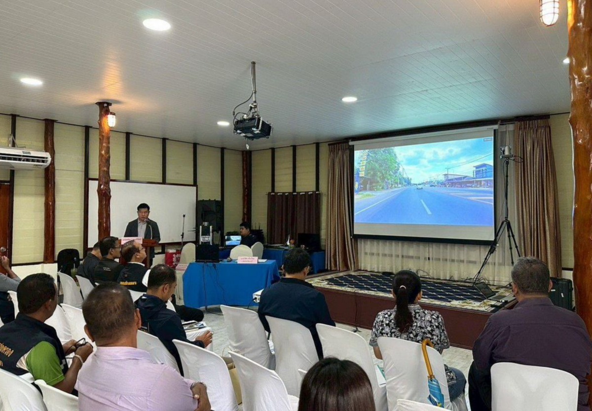
Krabi Province has formally launched a feasibility and design consultation for the expansion of Highway 4206 into a full four-lane route, marking a key step in preparations for the planned Ko Lanta bridge connection. The initiative was presented on 18 May 2026 at Wang Khok Sung Homestay in Ko Lanta District, Krabi, and brought together government agencies, state enterprises, local administrations, private organisations and members of the public.
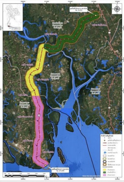
The opening seminar, chaired by Krabi Deputy Governor Winit Thiangthai, marked the first stakeholder meeting for the project consultancy study. The scheme covers a strategic 26.184-kilometre section of Highway 4206, from Huai Nam Khao Subdistrict in Khlong Thom District (km 0+910) to Ban Hua Hin Pier in Ko Lanta District (km 27+094), passing through Khlong Krad, Khlong Nam Daeng, agricultural zones, schools, communities, forest reserve areas and key local junctions.
The Department of Highways, through its Design and Survey Bureau, has appointed a consortium of consultants comprising Dao Ruek Communications Co Ltd, Professional Engineering Solution (PES) Co Ltd, and Trans Asia Consultant Co Ltd. The consultancy contract runs for 450 days and includes engineering surveys, environmental assessment, and public participation processes to determine the most suitable upgrade design options.
 At present, Highway 4206 varies between two and four lanes, with several bottlenecks. There are many non-urban sections where no central median exists. Urban stretches already feature four lanes with raised medians, but capacity constraints remain a concern given expected traffic growth linked to tourism development and the future Ko Lanta bridge project.
Officials described the route as a key strategic corridor connecting Krabi city and Krabi International Airport with southern Andaman tourism destinations. The proposed upgrade aims to improve safety, traffic flow and long-term economic development across the region, particularly in anticipation of increased visitor numbers once the bridge project is completed.
The consultants will analyse engineering constraints, environmental limitations and climate and safety risks to produce full four-lane design alternatives. These options will be presented for public consideration in the next consultation phase, with authorities confirming that all feedback will be incorporated into the final design blueprint.
Naewna reported that the Department of Highways will continue collecting stakeholder input and will publish ongoing project updates through official online channels as the study progresses.
Adapted by ASEAN Now Naewna 19 May 2026
Source: https://aseannow.com/topic/1394803-krabi-officials-launch-highway-4206-four-lane-upgrade-study/
Google Translation:
เจ้าหน้าที่จังหวัดกระบีเปิดการศึกษาความเป็นไปได้และออกแบบเพื่อขยายทางหลวงหมายเลข 4206 เป็นถนน 4 เลนเต็มรูปแบบ
ภาพประกอบโดย Naewna
ข่าวนี้ได้รับการสนับสนุนโดย FALLPROTEC บริษัทชั้นนำระดับโลกด้านการออกแบบและผลิตระบบป้องกันการตกจากที่สูงและโซลูชั่นการเข้าถึงที่สูง
จังหวัดกระบีได้เปิดการศึกษาความเป็นไปได้และออกแบบอย่างเป็นทางการสำหรับการขยายทางหลวงหมายเลข 4206 เป็นถนน 4 เลนเต็มรูปแบบ ซึ่งถือเป็นก้าวสำคัญในการเตรียมการเชื่อมต่อสะพานเกาะลันตาที่วางแผนไว้ โครงการนี้เปิดตัวเมื่อวันที่ 18 พฤษภาคม 2569 ณ โฮมสเตย์วังโคกซุง อำเภอเกาะลันตา จังหวัดกระบี โดยมีหน่วยงานภาครัฐ รัฐวิสาหกิจ องค์การบริหารส่วนท้องถิ่น องค์กรเอกชน และประชาชนทั่วไปเข้าร่วม
การสัมมนาเปิดโครงการ ซึ่งมีรองผู้ว่าราชการจังหวัดกระบี วินิต เทียนไทย เป็นประธาน ถือเป็นการประชุมผู้มีส่วนได้ส่วนเสียครั้งแรกสำหรับการศึกษาโครงการนี้ โครงการนี้ครอบคลุมช่วงยุทธศาสตร์ 26.184 กิโลเมตรของทางหลวงหมายเลข 4206 จากตำบลห้วยน้ำขาว อำเภอคลองทอม (กิโลเมตรที่ 0+910) ถึงท่าเรือบ้านหัวหิน อำเภอเกาะลันตา (กิโลเมตรที่ 27+094) โดยผ่านคลองกระด คลองน้ำแดง พื้นที่เกษตรกรรม โรงเรียน ชุมชน เขตป่าสงวน และทางแยกสำคัญต่างๆ
กรมทางหลวง โดยสำนักออกแบบและสำรวจ ได้แต่งตั้งกลุ่มที่ปรึกษาประกอบด้วย บริษัท ดาวเรือก คอมมิวนิเคชั่นส์ จำกัด บริษัท โปรเฟสชันแนล เอ็นจิเนียริ่ง โซลูชั่น (PES) จำกัด และบริษัท ทรานส์ เอเชีย คอนซัลแทนท์ จำกัด สัญญาที่ปรึกษามีระยะเวลา 450 วัน และรวมถึงการสำรวจทางวิศวกรรม การประเมินผลกระทบสิ่งแวดล้อม และกระบวนการมีส่วนร่วมของประชาชน เพื่อกำหนดทางเลือกการออกแบบการปรับปรุงที่เหมาะสมที่สุด
ปัจจุบัน ทางหลวงหมายเลข 4206 มีสองและสี่เลนสลับกันไป มีจุดคอขวดหลายจุด และมีหลายช่วงที่อยู่นอกเขตเมืองซึ่งไม่มีเกาะกลางถนน ถนนในเขตเมืองบางส่วนมีสี่เลนพร้อมเกาะกลางยกสูงอยู่แล้ว แต่ข้อจำกัดด้านความจุยังคงเป็นข้อกังวล เนื่องจากคาดการณ์ว่าปริมาณการจราจรจะเพิ่มขึ้นจากการพัฒนาการท่องเที่ยวและโครงการสะพานเกาะลันตาในอนาคต
เจ้าหน้าที่ระบุว่าเส้นทางนี้เป็นเส้นทางยุทธศาสตร์สำคัญที่เชื่อมต่อเมืองกระบีและสนามบินนานาชาติกระบีกับแหล่งท่องเที่ยวทางตอนใต้ของทะเลอันดามัน การปรับปรุงที่เสนอมีเป้าหมายเพื่อปรับปรุงความปลอดภัย การไหลเวียนของการจราจร และการพัฒนาเศรษฐกิจในระยะยาวทั่วทั้งภูมิภาค โดยเฉพาะอย่างยิ่งเพื่อรองรับจำนวนนักท่องเที่ยวที่เพิ่มขึ้นเมื่อโครงการสะพานเสร็จสมบูรณ์
ที่ปรึกษาจะวิเคราะห์ข้อจำกัดทางวิศวกรรม ข้อจำกัดด้านสิ่งแวดล้อม และความเสี่ยงด้านสภาพภูมิอากาศและความปลอดภัย เพื่อสร้างทางเลือกการออกแบบสี่เลนแบบเต็มรูปแบบ ทางเลือกเหล่านี้จะถูกนำเสนอต่อสาธารณะเพื่อพิจารณาในขั้นตอนการปรึกษาหารือครั้งต่อไป โดยหน่วยงานยืนยันว่าจะนำข้อเสนอแนะทั้งหมดไปรวมไว้ในแบบร่างการออกแบบขั้นสุดท้าย
นิตยสาร Naewna รายงานว่ากรมทางหลวงจะยังคงรวบรวมความคิดเห็นจากผู้มีส่วนได้ส่วนเสียและจะเผยแพร่ข้อมูลอัปเดตโครงการอย่างต่อเนื่องผ่านช่องทางออนไลน์อย่างเป็นทางการเมื่อการศึกษาคืบหน้า
เรียบเรียงโดย ASEAN Now Naewna 19 พฤษภาคม 2569