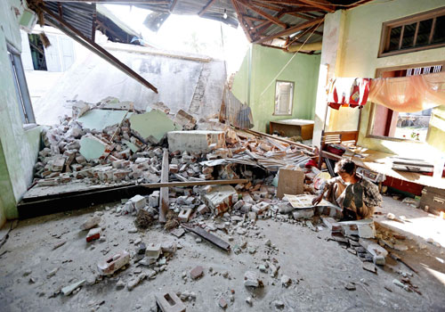

The Thabeikkyin earthquake in Mandalay Region in 2012 claimed 26 lives.
Faults lurking under Myanmar, as well as Bangladesh and India, could produce a magnitude-9.0 earthquake, according to a new study by Columbia University geologists.
The research, headed by Michael S Steckler of Columbia University’s Lamont-Doherty Earth Observatory, was published in the academic journal Nature Geosciences on July 11.
An Indian plate is stuck – according to the new study’s research models, which used data from Bangladeshi tracking stations – and the fault has been building up tension for more than 400 years. If that fault slips, according to researchers, it could produce a massive earthquake.
The megathrust fault, as it is called, has the same geographic characteristics as the fault that caused the magnitude-9.0 earthquake in Japan in 2011, according to National Geographic.
Researchers cannot estimate when the fault might actually slip.
“We at the Myanmar Earthquake Committee [MEC] cannot exactly say that the warnings of the researchers are possible or impossible,” said Daw Hla Hla Aung, a retired Yangon University geology professor. “We have already predicted that a megathrust earthquake could be underneath Burma but cannot know if it will become active and where exactly it is because of the lack of technology.”
According to the map produced by the Columbia University researchers, the quake region is in northeast India, extending to the northwest of Myanmar and Bangladesh. It is near the Kabaw fault and the Sagaing fault, located in Chin State and northwest Sagaing Region, two of Myanmar’s four major faultlines. The last major earthquake to hit the southern Sagaing fault struck Bago in 1930, measuring 7.3 on the Richter scale. The quake killed about 50 people in Yangon when the city had a population of only about 400,000.
“The nature of movement across the region suggested that the Indian plate was stuck, locked to the underside of northwest Myanmar’s mountains [Chin Hills],” a recent National Geographic article said.
But Myanmar doesn’t have the resources, like the GPS devices used in Bangladesh, that can predict when, where, and if an earthquake will occur, Daw Hla Hla Aung said.
There are eight activity-measuring GPS units in the entire country, she said, and none near the Kabaw fault or in the east or west of the country.
“A megathrust magnitude-9.0 earthquake has never struck in Burma according to the available historical information,” Daw Hla Hla Aung said.
In 1762, there was a megathrust earthquake in Bangladesh that caused a tsunami in the Bay of Bengal and in 1881 a major earthquake and tsunami struck the Andaman Islands.
“These are the historical earthquakes and it might be that they [the researchers] are predicting that the Shillong Plateau [which has caused earthquakes in the past] is currently unstable,” she said.
Earthquakes often reoccur after many years, she said.
If an earthquake strikes Myanmar at the magnitude predicted by the researchers, it would be the largest in the recorded history of the country, where preparation for a quake is almost nonexistent. Last year, UN-Habitat announced plans to develop earthquake response procedures for Yangon, which sits near the Sagaing fault. Experts called a magnitude-6.8 earthquake that struck in upper Myanmar in 2012 a “wake-up call”, citing a lack of preparedness.
Source: http://www.mmtimes.com/index.php/national-news/21538-fault-slip-under-myanmar-could-see-massive-earthquake-study-warns.html